IMAGES TAKEN NEAR TO
Old Bystock Drive, EXMOUTH, EX8 5EQ
Introduction
This page details the photographs taken nearby to Old Bystock Drive, EX8 5EQ by members of the Geograph project.
The Geograph project started in 2005 with the aim of publishing, organising and preserving representative images for every square kilometre of Great Britain, Ireland and the Isle of Man.

There are currently over 7.5m images from over14,400 individuals and you can help contribute to the project by visiting https://www.geograph.org.uk
Image Map
Images are licensed for reuse under creativecommons.org/licenses/by-sa/2.0
Notes
- Clicking on the map will re-center to the selected point.
- The higher the marker number, the further away the image location is from the centre of the postcode.
Image Listing (10 Images Found)
Images are licensed for reuse under creativecommons.org/licenses/by-sa/2.0
Image
Details
Distance
1

A private road disappears into the woods at Bystock Court
Image: © Sarah Charlesworth
Taken: 28 Nov 2009
0.09 miles


5
Houses at Withycombe Barton
The access road leads to the church of St John in the Wilderness
Image: © David Smith
Taken: 12 Jul 2011
0.18 miles
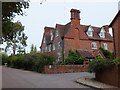
6
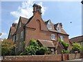
Withycombe Barton, Exmouth
The C19 brick house is now divided in two. The "Large southern end gable with triple chimney and blind arch in gable" http://www.britishlistedbuildings.co.uk/en-87513-withycombe-barton-exmouth are visible in this photo, a closer view of Image, which was taken the day after.
Image: © Derek Harper
Taken: 11 Jul 2011
0.18 miles
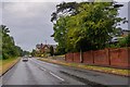
7
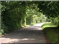
St John's Road, Withycombe
The road is passing St Johns Farm Caravan & Camping Park on the right, and approaching Withycombe Barton.
Image: © Derek Harper
Taken: 11 Jul 2011
0.19 miles
8
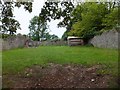
Private burial ground at St John in the Wilderness church
A small, locked, burial ground, adjacent to the churchyard
Image: © David Smith
Taken: 12 Jul 2011
0.23 miles
9
Exmouth : Dinan Way
Looking along Dinan Way.
Image: © Lewis Clarke
Taken: 13 Jun 2020
0.23 miles
10

Church of St John in the Wilderness
Another view of Image The tower is C14, but most of the church was rebuilt between 1926-37. "In the Wilderness" because of its relative isolation; the church guide recounts that the roads to the villages it served were often impassable in winter. In 1788, the building was in such a state that the vicar petitioned for it to be pulled down; in the event, the nave and chancel were demolished. http://www.britishlistedbuildings.co.uk/en-87519-church-of-st-john-in-the-wilderness-exmou
Image: © Derek Harper
Taken: 9 Jul 2010
0.25 miles