IMAGES TAKEN NEAR TO
Church Street, DAWLISH, EX7 9QR
Introduction
This page details the photographs taken nearby to Church Street, EX7 9QR by members of the Geograph project.
The Geograph project started in 2005 with the aim of publishing, organising and preserving representative images for every square kilometre of Great Britain, Ireland and the Isle of Man.

There are currently over 7.5m images from over14,400 individuals and you can help contribute to the project by visiting https://www.geograph.org.uk
Image Map
Images are licensed for reuse under creativecommons.org/licenses/by-sa/2.0
Notes
- Clicking on the map will re-center to the selected point.
- The higher the marker number, the further away the image location is from the centre of the postcode.
Image Listing (130 Images Found)
Images are licensed for reuse under creativecommons.org/licenses/by-sa/2.0
Image
Details
Distance
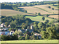
1
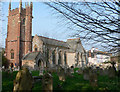
Dawlish Parish Church
St Gregory's is a friendly family Church, within the Diocese of Exeter of the Church of England. It is the Parish Church of Dawlish situated west from the hospital.
Image: © paul dickson
Taken: 22 Apr 2008
0.02 miles
2
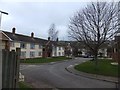
Newhay Close
A short cul-de-sac with modern houses
Image: © David Smith
Taken: 7 Feb 2012
0.03 miles
3

St Gregory the Great's church, Dawlish - interior
Image: © Ruth Sharville
Taken: 23 May 2015
0.03 miles
4
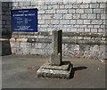
Old Wayside Cross - moved to Dawlish churchyard
Dawlish Churchyard Cross, old shaft and base, by the path, in parish of Dawlish (Teignbridge District), by the Southeast side of church tower, in tarmac path.
Grade II listed.
List Entry Number: 1164206 https://historicengland.org.uk/listing/the-list/list-entry/1164206
Surveyed
Milestone Society National ID: DVTE_DAW03
Image: © Alan Rosevear
Taken: 11 May 2009
0.04 miles
5

Dawlish : Church Street
Church Street with St Gregory's Parish Church at the end of the road.
Image: © Lewis Clarke
Taken: 27 Mar 2011
0.04 miles
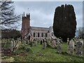
6
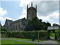
Church of St Gregory the Great, Dawlish
The usual pedestrian and vehicle approach to the church is from the town centre to the east, but the best view is from the open field called the Newhay to the north-west.
Historically the church was dedicated to St Gregory, with a reference as early as 1301. In 1824 it was rebuilt, apart from the medieval tower which survives, and for that reason is listed Grade II* (List entry 1164203). The architect for the rebuilding was Andrew Patey, who also built the daughter church of St Michael the Archangel in Teignmouth.
Some time around the early 1850s the name was changed to St Michael, possibly because the anniversary of the consecration of the building was on 27th September, two days before Michaelmas, or to match the name of the daughter church, but the most likely explanation seems to lie with the vicar at the time, the Revd Edward Fursdon (vicar 1846-1864). He was the second son of the Fursdons of Fursdon House, Cadbury, Devon Image whose church is also dedicated to St Michael Image After Fursdon's time, the building was further altered in 1873-5. The dedication to St Gregory was reinstated in 1924 by the Revd Frank Simmons who 'having considered the history of the parish and consulted the lay representatives and the Diocesan authorities offered to hold a rededication service'(Dawlish Gazette 15th March 1924). The suffix 'the Great' appears to be a later addition still. Credit for the historical research here goes to David Allanach of the Dawlish Local History Group.
Image: © Stephen Craven
Taken: 14 Jul 2021
0.04 miles
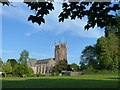
7
St Gregory's church, Dawlish
The parish church of St Gregory the Great, seen from a footpath on the hillside to the north of the town.
Image: © Stephen Craven
Taken: 26 Sep 2010
0.04 miles
9
St Gregory the Great's church, Dawlish
Image: © Ruth Sharville
Taken: 23 May 2015
0.05 miles
10
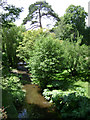
Dawlish Water approaches Church Street, Dawlish
Church Street bridges this small river, extensively modified in the early 19th century. To the right are the grounds of Bridge House.
Image: © Robin Stott
Taken: 27 Jun 2009
0.05 miles