IMAGES TAKEN NEAR TO
Meldrum Close, DAWLISH, EX7 9JL
Introduction
This page details the photographs taken nearby to Meldrum Close, EX7 9JL by members of the Geograph project.
The Geograph project started in 2005 with the aim of publishing, organising and preserving representative images for every square kilometre of Great Britain, Ireland and the Isle of Man.

There are currently over 7.5m images from over14,400 individuals and you can help contribute to the project by visiting https://www.geograph.org.uk
Image Map
Images are licensed for reuse under creativecommons.org/licenses/by-sa/2.0
Notes
- Clicking on the map will re-center to the selected point.
- The higher the marker number, the further away the image location is from the centre of the postcode.
Image Listing (630 Images Found)
Images are licensed for reuse under creativecommons.org/licenses/by-sa/2.0
Image
Details
Distance
1
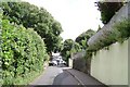
Old Gatehouse Road, Dawlish
The name echoes Gatehouse Farm to the north. Here the road is nearing its junction with East Cliff Close, a modern cul-de-sac on the left, then East Cliff Road. This is the edge of Victorian Dawlis, signalled by its Holm Oaks and grey limestone walls.
Image: © Robin Stott
Taken: 19 Jul 2009
0.03 miles
2
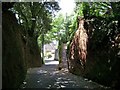
Strand Hill, Dawlish
Dawlish has a number of these hair-raising steep narrow hills. Footpath No 20 takes off on the right.
Image: © Robin Stott
Taken: 19 Jul 2009
0.03 miles
3
Strand Hill, Dawlish
Seen from Footpath No 20. Changes were photographed in 2016: see Image
Image: © Robin Stott
Taken: 19 Jul 2009
0.03 miles
4

Dawlish from the air
Looking across Luscombe Wood, Beyond the town is the coast to Langstone Rock, Dawlish Warren, with the spit of Dawlish Warren at top left across the Exe estuary.
Image: © Derek Harper
Taken: 20 Feb 2018
0.03 miles
5
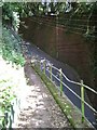
Rock anchors
These rock anchors were installed recently (C.2009?) to the retaining walls of gardens above this public footpath on the hillside above Dawlish town centre.
Image: © Stephen Craven
Taken: 3 Aug 2011
0.03 miles
6

Strand Hill, Dawlish
A steep road, seen here at the junction with the even steeper Meldrum Close.
Image: © Stephen Craven
Taken: 11 Jul 2021
0.04 miles
7
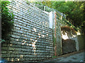
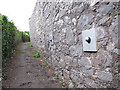
West side of Strand Hill
The road is in a deep cutting through unstable sandstone, and the blocks here are the facing to an engineered retaining wall built following a landslide.
Image: © Stephen Craven
Taken: 29 Aug 2016
0.05 miles
8

Looking down on Strand Hill from the footpath
Looking down from the footpath Image
Image: © Stephen Craven
Taken: 29 Aug 2016
0.05 miles
9
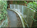
Fence to rebuilt footpath
The path had been rebuilt following a landslide. Image shows the same location seven years earlier with a less substantial fence.
Image: © Stephen Craven
Taken: 29 Aug 2016
0.05 miles
10
Learning to fly
This injured herring gull chick was being cared for by a local resident. It was at the stage of flapping its wings to try to fly, but without a parent to teach it was some way off succeeding yet.
Image: © Stephen Craven
Taken: 10 Jul 2014
0.05 miles