IMAGES TAKEN NEAR TO
Commercial Road, DAWLISH, EX7 9HU
Introduction
This page details the photographs taken nearby to Commercial Road, EX7 9HU by members of the Geograph project.
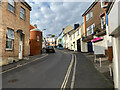
The Geograph project started in 2005 with the aim of publishing, organising and preserving representative images for every square kilometre of Great Britain, Ireland and the Isle of Man.

There are currently over 7.5m images from over14,400 individuals and you can help contribute to the project by visiting https://www.geograph.org.uk
Image Map
Images are licensed for reuse under creativecommons.org/licenses/by-sa/2.0
Notes
- Clicking on the map will re-center to the selected point.
- The higher the marker number, the further away the image location is from the centre of the postcode.
Image Listing (846 Images Found)
Images are licensed for reuse under creativecommons.org/licenses/by-sa/2.0
Image
Details
Distance
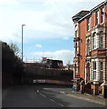
1

Iddesleigh Terrace, Exeter Road, Dawlish
The view is from the clifftop open space (Thompson's Path) past the Lanherne retirement housing, right, and across Exeter Road.
Image: © Robin Stott
Taken: 20 Mar 2022
0.01 miles
2
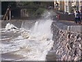
Dawlish Seawall with sea breaking over railway
Sea breaking over seawall and railway
Image: © stewart michael
Taken: Unknown
0.01 miles
3
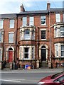
Iddesleigh Terrace
A delightfully detailed Victorian terrace. The datestone is 1887.
Image: © Michael Dibb
Taken: 28 May 2017
0.01 miles
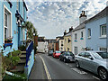
4
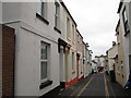
Strand Hill, Dawlish
The lower part of the hill is less steep, but even narrower, than the upper.
Image: © Stephen Craven
Taken: 3 Aug 2011
0.01 miles
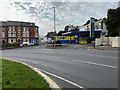
6
Sharp bend in Iddesleigh Terrace, Dawlish
Directions to Exeter are painted on the wall ahead.
Image: © John C
Taken: 28 Apr 2018
0.02 miles
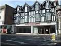
7
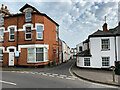
High Street turning off Exeter Road, Dawlish
'Dawlish 2 'n' 4 Repair Centre' looks as though it was once a petrol filling station. On the left is the north end of Iddesleigh Terrace Image and Image
Image: © Robin Stott
Taken: 20 Mar 2022
0.02 miles
8
Down Strand Hill, Dawlish
A late 19th-century map records this as Park Street.
Image: © Robin Stott
Taken: 20 Mar 2022
0.02 miles
10
North up Strand Hill
A late 19th-century map records this as Park Street.
Image: © Robin Stott
Taken: 20 Mar 2022
0.02 miles