IMAGES TAKEN NEAR TO
Meadow Park, DAWLISH, EX7 9BT
Introduction
This page details the photographs taken nearby to Meadow Park, EX7 9BT by members of the Geograph project.
The Geograph project started in 2005 with the aim of publishing, organising and preserving representative images for every square kilometre of Great Britain, Ireland and the Isle of Man.

There are currently over 7.5m images from over14,400 individuals and you can help contribute to the project by visiting https://www.geograph.org.uk
Image Map
Images are licensed for reuse under creativecommons.org/licenses/by-sa/2.0
Notes
- Clicking on the map will re-center to the selected point.
- The higher the marker number, the further away the image location is from the centre of the postcode.
Image Listing (50 Images Found)
Images are licensed for reuse under creativecommons.org/licenses/by-sa/2.0
Image
Details
Distance
1
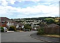
Looking from Meadow Rise across Dawlish to West Cliff housing
Image: © David Gearing
Taken: 17 Jul 2010
0.03 miles
2
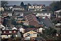
Dawlish : Houses on the hillside
Looking up towards the hillside from Church Street. The road seen here is Upper Longlands.
Image: © Lewis Clarke
Taken: 27 Mar 2011
0.03 miles
3
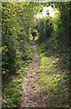
Dawlish footpath 15
Looking to the right from the gate shown in Image
Image: © Derek Harper
Taken: 20 Oct 2019
0.04 miles
4

Grassy field above Dawlish
A path around the top of the same field as Image], with a mobile phone mast on a neighbouring hill and a view up to Haldon.
Image: © Derek Harper
Taken: 20 Oct 2019
0.05 miles
5
Path junction near The Humpy
Looking behind the camera in Image], with Dawlish footpath 14 turning left uphill, and footpath 15 heading right through the kissing gate.
Image: © Derek Harper
Taken: 20 Oct 2019
0.06 miles
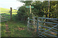
6
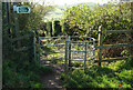
Kissing gate by The Humpy
Shown from a different angle in Image This is Dawlish footpath 15 heading down towards Badlake Hill.
Image: © Derek Harper
Taken: 4 Nov 2020
0.06 miles
7
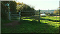
Gates near The Humpy
Looking the other way from Image], with Dawlish footpath 14 going through the gate on the left having just collected Dawlish footpath 13.
Image: © Derek Harper
Taken: 4 Nov 2020
0.08 miles
8
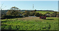
Field by The Humpy
Houses on the Humpy are on the left. This is a view from the gate shown in Image
Image: © Derek Harper
Taken: 4 Nov 2020
0.08 miles
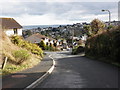
10
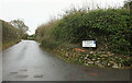
Badlake Hill
Passing the junction with The Humpy. From here on, the lane is rural.
Image: © Derek Harper
Taken: 12 Dec 2021
0.09 miles