IMAGES TAKEN NEAR TO
Branscombe Lane, DAWLISH, EX7 0QU
Introduction
This page details the photographs taken nearby to Branscombe Lane, EX7 0QU by members of the Geograph project.
The Geograph project started in 2005 with the aim of publishing, organising and preserving representative images for every square kilometre of Great Britain, Ireland and the Isle of Man.

There are currently over 7.5m images from over14,400 individuals and you can help contribute to the project by visiting https://www.geograph.org.uk
Image Map
Images are licensed for reuse under creativecommons.org/licenses/by-sa/2.0
Notes
- Clicking on the map will re-center to the selected point.
- The higher the marker number, the further away the image location is from the centre of the postcode.
Image Listing (24 Images Found)
Images are licensed for reuse under creativecommons.org/licenses/by-sa/2.0
Image
Details
Distance
1
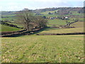
Branscombe Lane, near Dawlish
Looking SSW from the centre of this square down the lane past Branscombe Cottage to the farms of square Image and the Long Lane ridge above Dawlish Water. 9:07 am.
Image: © Derek Harper
Taken: 29 Mar 2006
0.06 miles
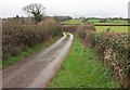
2
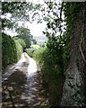
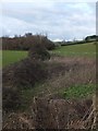
Branscombe Lane
This northern half of the lane is notable for a series of widely-spaced massive trees.
Image: © Robin Stott
Taken: 19 Jul 2009
0.06 miles
3

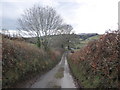
Branscombe Lane below Branscombe Cottage
Image: © Robin Stott
Taken: 19 Jul 2009
0.09 miles
4
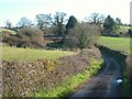
Branscombe Lane
The lane dips across a valley and climbs past a shed; the roof and chimney of Branscombe Cottage are right of centre above the laneside tree.
Image: © Derek Harper
Taken: 29 Mar 2006
0.09 miles
7
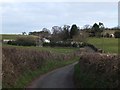
Branscombe Lane leading up to Branscombe Cottage
Image: © David Smith
Taken: 23 Jan 2012
0.12 miles
8
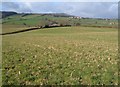
Field by Port Road
In the angle between Port Road and Branscombe Lane, this field also occupies the foreground of Image As with Image, the ridge-top houses in the distance are on Long Lane, and in Image Beyond them is Little Haldon.
Image: © Derek Harper
Taken: 29 Mar 2006
0.14 miles
9
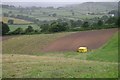
Shelter on crop land west of Langdon Hospital
The pylons, top centre, mark the slight dip in the Long Lane ridge above Houndspool
Image: © Robin Stott
Taken: 19 Jul 2009
0.14 miles
10
Branscombe Lane
From where it crosses a small stream (the Shutterton Brook, I would say), looking up the lane towards its junction with Hensford Road.
Image: © Derek Harper
Taken: 1 Feb 2017
0.18 miles