IMAGES TAKEN NEAR TO
DAWLISH, EX7 0QL
Introduction
This page details the photographs taken nearby to EX7 0QL by members of the Geograph project.
The Geograph project started in 2005 with the aim of publishing, organising and preserving representative images for every square kilometre of Great Britain, Ireland and the Isle of Man.

There are currently over 7.5m images from over14,400 individuals and you can help contribute to the project by visiting https://www.geograph.org.uk
Image Map
Images are licensed for reuse under creativecommons.org/licenses/by-sa/2.0
Notes
- Clicking on the map will re-center to the selected point.
- The higher the marker number, the further away the image location is from the centre of the postcode.
Image Listing (28 Images Found)
Images are licensed for reuse under creativecommons.org/licenses/by-sa/2.0
Image
Details
Distance
1
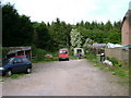
Area behind cottages, Lower Dawlish Water Road
Image: © Robin Stott
Taken: 20 May 2009
0.09 miles
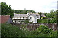
2
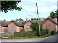
Well-connected cottages, south end of Lower Dawlish Water Road
The cottages face Bere Hill, the continuation downhill of Luscombe Hill.
Image: © Robin Stott
Taken: 20 May 2009
0.09 miles
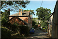
3
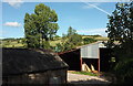
Farm buildings, Radfords
By Lower Dawlish Water Road.
Image: © Derek Harper
Taken: 25 Sep 2018
0.09 miles
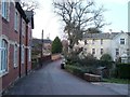
4
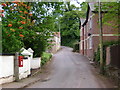
Houses, Lower Dawlish Water Road
The flowering tree is the Chilean fire bush, Embothrium coccineum, only hardy in the south and west. That reminds me of Robert Frost's poem 'There are roughly zones'. Sorry, I forgot to look at the letter box. The reverse view is Image
Image: © Robin Stott
Taken: 20 May 2009
0.10 miles
5
Houses near Radfords
Much refurbishment appears to have been undertaken in this hamlet, in addition to the new-build up the road Image
Image: © Robin Stott
Taken: 20 May 2009
0.10 miles
6
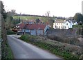
Lower Dawlish Water
Approaching a hamlet on the Lower Dawlish Water Road. On the right is the stucco Coombe Brook http://www.britishlistedbuildings.co.uk/en-84391-coombe-brook-dawlish-devon .
Image: © Derek Harper
Taken: 18 Mar 2006
0.11 miles
7
Lower Dawlish Water Road at Radfords
On the right is the farm building on the left of Image On the left here are Shiverstone Cottages.
Image: © Derek Harper
Taken: 25 Sep 2018
0.12 miles
8
Lower Dawlish Water
A reverse view of the scene in Image On the left are Shiverstone Cottages. On the right is the C19 Coombe Brook http://www.britishlistedbuildings.co.uk/en-84391-coombe-brook-dawlish-devon . You can just make out the postbox in the centre by the gatepost - I'm afraid I didn't take the number or reign either!
Image: © Derek Harper
Taken: 18 Mar 2006
0.12 miles
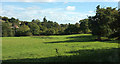
9
Dawlish Water valley
From the same spot as Image, looking to the left up the valley more, again with Fairfield House prominent. Littlestone is the house on the left.
Image: © Derek Harper
Taken: 18 Mar 2006
0.12 miles
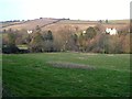
10
Dawlish Water valley
Looking right from Image] down the valley floor.
Image: © Derek Harper
Taken: 25 Sep 2018
0.13 miles