IMAGES TAKEN NEAR TO
Marston Close, DAWLISH, EX7 0EZ
Introduction
This page details the photographs taken nearby to Marston Close, EX7 0EZ by members of the Geograph project.
The Geograph project started in 2005 with the aim of publishing, organising and preserving representative images for every square kilometre of Great Britain, Ireland and the Isle of Man.

There are currently over 7.5m images from over14,400 individuals and you can help contribute to the project by visiting https://www.geograph.org.uk
Image Map (Loading...)


Getting Data...Please wait
Leaflet Map data © OpenStreetMap
Images are licensed for reuse under creativecommons.org/licenses/by-sa/2.0
Notes
- Clicking on the map will re-center to the selected point.
- The higher the marker number, the further away the image location is from the centre of the postcode.
Image Listing (143 Images Found)
Images are licensed for reuse under creativecommons.org/licenses/by-sa/2.0
Image
Details
Distance
1
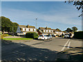
Elm Grove Drive, Dawlish
Elm Grove was the name of a large 19th century private house which stood behind the trees to the left of the photo. It was demolished in the late 20th century and the land around it used for housing.
Image: © Stephen Craven
Taken: 27 Oct 2019
0.05 miles
2
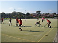
Dawlish men's hockey match in progress
Image: © Roger Cornfoot
Taken: 11 Oct 2008
0.06 miles
4
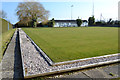
Bowling green and pavilion, Marina Bowling Club, Sandy Lane, north Dawlish
Image: © Robin Stott
Taken: 14 Mar 2016
0.07 miles
5

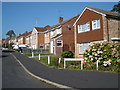
Sandy Lane
The road leads to the Dawlish Leisure Centre.
Image: © Michael Dibb
Taken: 1 Jun 2017
0.07 miles
6
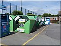
Recycling bank
Seen in Sandy Lane car park.
Image: © Michael Dibb
Taken: 1 Jun 2017
0.09 miles
7
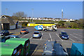
Car park, toilets and recycling by the tennis courts, Sandy Lane, Dawlish
The three hard tennis courts are behind the camera and to the right. To the left is a large all-weather multi-sports pitch. Across Sandy Lane are public sports pitches and the clubhouse of Dawlish United Youth & mini Soccer FC. Houses in Henty Avenue overlook the ground.
Image: © Robin Stott
Taken: 14 Mar 2016
0.10 miles
8
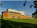
Dawlish Leisure Centre
The swimming pool opened in 1974; in 1994 a sports hall was added and it became Dawlish Leisure Centre.
Image: © Stephen Craven
Taken: 27 Oct 2019
0.11 miles
9
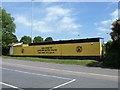
Football ground
Seen from the car park in Sany Lane is the home of Dawlish United.
Image: © Michael Dibb
Taken: 1 Jun 2017
0.11 miles
10
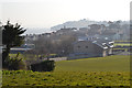
North Dawlish from the former Pitch and Putt, Sandy Lane
Dawlish Leisure Centre is in the middle distance with Dawlish Community College beyond it. Along the coast the Parson and Clerk, the sandstone formation below Hole Head, is grey in the distance. At this time of year, mid-March, the Pitch and Putt looks abandoned and overgrown but we'll see later if it's brought into use again.
Image: © Robin Stott
Taken: 14 Mar 2016
0.11 miles