IMAGES TAKEN NEAR TO
East Cliff Road, DAWLISH, EX7 0EL
Introduction
This page details the photographs taken nearby to East Cliff Road, EX7 0EL by members of the Geograph project.
The Geograph project started in 2005 with the aim of publishing, organising and preserving representative images for every square kilometre of Great Britain, Ireland and the Isle of Man.

There are currently over 7.5m images from over14,400 individuals and you can help contribute to the project by visiting https://www.geograph.org.uk
Image Map
Images are licensed for reuse under creativecommons.org/licenses/by-sa/2.0
Notes
- Clicking on the map will re-center to the selected point.
- The higher the marker number, the further away the image location is from the centre of the postcode.
Image Listing (650 Images Found)
Images are licensed for reuse under creativecommons.org/licenses/by-sa/2.0
Image
Details
Distance
1
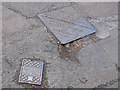
Service boxes
The nearer of these two on East Cliff Road has the inscription "DUC SVB" which I interpret as "Dawlish Urban Council sluice valve box". DUC no longer exists (probably swallowed up in the 1974 reforms?). The other is a more standard Stanton & Staveley sewer manhole cover (c.1980-2000?).
Image: © Stephen Craven
Taken: 4 Aug 2011
0.01 miles
2

Outlook Court
Sheltered housing on East Cliff Road.
Image: © Stephen Craven
Taken: 4 Aug 2011
0.03 miles
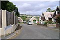
3

East Cliff Road, Dawlish
Holm Oaks and an Indian Bean Tree (Paulownia) planted in the 19th century survive new development.
Image: © Robin Stott
Taken: 19 Jul 2009
0.05 miles
4
East Cliff Close, Dawlish
A steep cul-de-sac with, from the top, a view across to the Henty Avenue residential area in the opposite corner of the square.
Image: © Robin Stott
Taken: 19 Jul 2009
0.05 miles
5

East side of Strand Hill
Looking down from the elevated footpath across the road Image The road is in a deep cutting through unstable sandstone.
Image: © Stephen Craven
Taken: 29 Aug 2016
0.05 miles
6
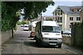
East Cliff Road, Dawlish
A road in transition, with buildings of all ages and sizes on the south side, while unseen properties and developments on the north side are hidden among dense trees and shrubs.
Image: © Robin Stott
Taken: 19 Jul 2009
0.06 miles
7
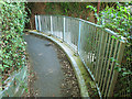
Fence to rebuilt footpath
The path had been rebuilt following a landslide. Image shows the same location seven years earlier with a less substantial fence.
Image: © Stephen Craven
Taken: 29 Aug 2016
0.07 miles
8
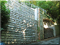
West side of Strand Hill
The road is in a deep cutting through unstable sandstone, and the blocks here are the facing to an engineered retaining wall built following a landslide.
Image: © Stephen Craven
Taken: 29 Aug 2016
0.07 miles
9

Looking down on Strand Hill from the footpath
Looking down from the footpath Image
Image: © Stephen Craven
Taken: 29 Aug 2016
0.07 miles
10

Strand Hill, Dawlish
A steep road, seen here at the junction with the even steeper Meldrum Close.
Image: © Stephen Craven
Taken: 11 Jul 2021
0.08 miles