IMAGES TAKEN NEAR TO
Leyfield Walk, DAWLISH, EX7 0EF
Introduction
This page details the photographs taken nearby to Leyfield Walk, EX7 0EF by members of the Geograph project.
The Geograph project started in 2005 with the aim of publishing, organising and preserving representative images for every square kilometre of Great Britain, Ireland and the Isle of Man.

There are currently over 7.5m images from over14,400 individuals and you can help contribute to the project by visiting https://www.geograph.org.uk
Image Map
Images are licensed for reuse under creativecommons.org/licenses/by-sa/2.0
Notes
- Clicking on the map will re-center to the selected point.
- The higher the marker number, the further away the image location is from the centre of the postcode.
Image Listing (62 Images Found)
Images are licensed for reuse under creativecommons.org/licenses/by-sa/2.0
Image
Details
Distance
1
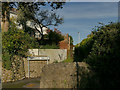
Leyfield Walk, off Gatehouse Hill
Gatehouse Hill would have been a country lane until relatively recently but now has several housing developments along its length including this one (Gatehouse Close). From old maps it is evident that the footpath follows the line of an old field boundary of which no other trace remains.
Image: © Stephen Craven
Taken: 27 Oct 2019
0.02 miles
2
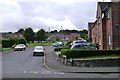
Newlands, Dawlish
Twentieth century housing around a spacious green, now enhanced by a MUGA (multi-use games area).
Image: © Robin Stott
Taken: 19 Jul 2009
0.06 miles
3
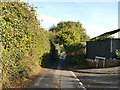
Junction of Wallace Avenue and Gatehouse Hill
Gatehouse Hill would have been a country lane until relatively recently but now has several housing developments along its length.
Image: © Stephen Craven
Taken: 27 Oct 2019
0.07 miles
4
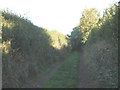
Footpath beyond Sutton Close
Sutton Close is a dead-end street for traffic, but continues in the form of a farm track with public footpath status.
Image: © Stephen Craven
Taken: 26 Sep 2010
0.07 miles
5
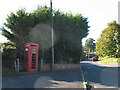
Vandalised phone box
Despite the sign "coins not accepted here" (i.e. only credit/debit cards can be used to make calls) this traditional red phone box had been vandalised. It is on the corner of Gatehouse Hill and Newlands.
Image: © Stephen Craven
Taken: 26 Sep 2010
0.07 miles
7
Near the top of Gatehouse Hill, Dawlish
A pair of neat semi-detached brick cottages fronts straight on to the road.
Image: © Robin Stott
Taken: 19 Jul 2009
0.09 miles
8

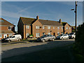
The Paddock, Dawlish
A modern residential cul de sac on Gatehouse Hill, just above the point where it becomes a footpath.
Image: © Derek Harper
Taken: 7 Apr 2009
0.09 miles
9
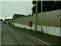
Newlands, off Gatehouse Hill
Newlands is probably a post-War development as it appears on the 1963 OS map.
Image: © Stephen Craven
Taken: 27 Oct 2019
0.09 miles
10

Footpath to Dawlish
Dawlish footpath 14 descends beside a field once part of Pathfields Nursery, with the sea visible ahead.
Image: © Derek Harper
Taken: 20 Oct 2019
0.10 miles