IMAGES TAKEN NEAR TO
Penhayes Road, EXETER, EX6 8NR
Introduction
This page details the photographs taken nearby to Penhayes Road, EX6 8NR by members of the Geograph project.
The Geograph project started in 2005 with the aim of publishing, organising and preserving representative images for every square kilometre of Great Britain, Ireland and the Isle of Man.

There are currently over 7.5m images from over14,400 individuals and you can help contribute to the project by visiting https://www.geograph.org.uk
Image Map
Images are licensed for reuse under creativecommons.org/licenses/by-sa/2.0
Notes
- Clicking on the map will re-center to the selected point.
- The higher the marker number, the further away the image location is from the centre of the postcode.
Image Listing (98 Images Found)
Images are licensed for reuse under creativecommons.org/licenses/by-sa/2.0
Image
Details
Distance
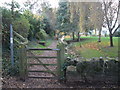
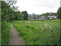
2
Footpath beside a stream in Kenton
The stream has been channelled into a straight course through the built-up area of the village
Image: © David Smith
Taken: 26 Oct 2013
0.05 miles
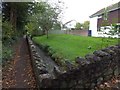
3
Slittercombe Lane
A country lane running along the northern edge of Kenton village. Beside it on the right are the rears of modern properties on Penhayes Road.
Image: © Derek Harper
Taken: 4 Nov 2009
0.06 miles
4
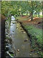
Stream, Kenton
Kenton Footpath 1 runs alongside the stream from Image to The Green.
Image: © Derek Harper
Taken: 4 Nov 2009
0.06 miles
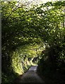
5
The path to Kenton
Approaching the village from Powderham Park.
Image: © Jonathan Thacker
Taken: 16 May 2011
0.06 miles
6
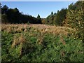
Grassland near Slittercombe Lane
Taken from Kenton Footpath 10 as it runs along the perimeter fence of Powderham Deer Park (behind the camera). The triangular area of grassland is between a boot-shaped area of woodland which on its far side adjoins Slittercombe Lane (left) and Kenton Footpath 1 (right). This is on the southern slopes of the Kenn valley.
Image: © Derek Harper
Taken: 4 Nov 2009
0.07 miles
7

Footpath in flood plain of River Kenn
The stream on the left has come from the village of Kenton, and flows to join the Kenn
Image: © David Smith
Taken: 26 Oct 2013
0.08 miles
8
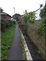
Footpath beside a stream in Kenton
This footpath leads from the main road in Kenton to the River Kenn, and a path across Powderham Park
Image: © David Smith
Taken: 26 Oct 2013
0.10 miles
9
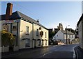
Fore Street, Kenton
The A379 just east of The Green, climbing up a terrace of the Kenn valley. This is an awkward stretch of a busy main road for pedestrians and motorists. The zigzag white lines indicate the proximity of a pedestrian crossing behind the camera. On the left is the former Devon Arms, since 2007 the Chi oriental restaurant.
Image: © Derek Harper
Taken: 4 Nov 2009
0.10 miles
10

Footpath to Kenton
Looking along Kenton Footpath 1 from near its junction with Kenton Footpath 10, towards Kenton, with the tower of Image in the centre, behind housing on Orchard Way.
Image: © Derek Harper
Taken: 4 Nov 2009
0.11 miles