IMAGES TAKEN NEAR TO
Powderham, EXETER, EX6 8JP
Introduction
This page details the photographs taken nearby to EX6 8JP by members of the Geograph project.
The Geograph project started in 2005 with the aim of publishing, organising and preserving representative images for every square kilometre of Great Britain, Ireland and the Isle of Man.

There are currently over 7.5m images from over14,400 individuals and you can help contribute to the project by visiting https://www.geograph.org.uk
Image Map
Images are licensed for reuse under creativecommons.org/licenses/by-sa/2.0
Notes
- Clicking on the map will re-center to the selected point.
- The higher the marker number, the further away the image location is from the centre of the postcode.
Image Listing (22 Images Found)
Images are licensed for reuse under creativecommons.org/licenses/by-sa/2.0
Image
Details
Distance
1

Powderham New Plantation
Didn't want to go in anyway. Powderham plantations old and new run along the north-eastern valley side of the River Kenn, along the ridge separating it from the Exe.
Image: © Derek Harper
Taken: 26 Apr 2006
0.07 miles
2
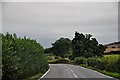
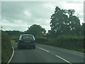
Teignbridge : The A379
The A379 approaching Kenton Bridge in Teignbridge.
Image: © Lewis Clarke
Taken: 12 Sep 2013
0.08 miles
3
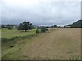
Field and stream south of Powderham New Plantation
The plantation is on the right; the field is bounded on the left by a small stream, which runs parallel to the River Kenn which flows through the next field to the left.
Image: © David Smith
Taken: 21 Aug 2016
0.08 miles
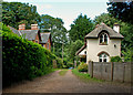
4
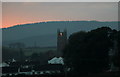
Kenton Church
Taken from public footpath by Powderham Castle
Image: © Brian Bailey
Taken: 25 Dec 2005
0.10 miles
5
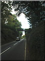
Powderham Arch
This pedestrian footbridge, above the busy A379 from Exeter to Dawlish, connects the old and new woodland plantations, on the Powderham Estate.
Image: © Roger Cornfoot
Taken: 1 Oct 2008
0.10 miles
6
Bridge over the river Kenn on the A379 heading for Kenton
Image: © Rob Purvis
Taken: 4 Sep 2009
0.12 miles
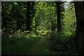
8
A track which leads into Powderham Old Plantation
Image: © Roger A Smith
Taken: 2 Jul 2016
0.13 miles
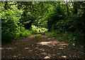
10

Powderham Old Plantation
View from the cycle path (NCN2) with a heron stalking in the ditch adjacent to the railway line.
Image: © David Smith
Taken: 29 Jun 2020
0.14 miles