IMAGES TAKEN NEAR TO
Jupes Close, EXETER, EX6 8BN
Introduction
This page details the photographs taken nearby to Jupes Close, EX6 8BN by members of the Geograph project.
The Geograph project started in 2005 with the aim of publishing, organising and preserving representative images for every square kilometre of Great Britain, Ireland and the Isle of Man.

There are currently over 7.5m images from over14,400 individuals and you can help contribute to the project by visiting https://www.geograph.org.uk
Image Map
Images are licensed for reuse under creativecommons.org/licenses/by-sa/2.0
Notes
- Clicking on the map will re-center to the selected point.
- The higher the marker number, the further away the image location is from the centre of the postcode.
Image Listing (54 Images Found)
Images are licensed for reuse under creativecommons.org/licenses/by-sa/2.0
Image
Details
Distance
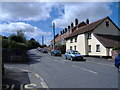
1

Police helicopter hovers above Exminster
Image: © Roger Cornfoot
Taken: 21 Mar 2010
0.03 miles
2
Main street, Exminster
Once the main road between Exeter and Dawlish.
Image: © Roger Cornfoot
Taken: 12 Oct 2007
0.04 miles
3
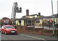
The fire brigade in action, at the Royal Oak, Exminster
Image: © Roger Cornfoot
Taken: 30 Mar 2009
0.04 miles
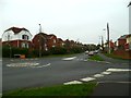
4

Exminster : Main Road
Heading down Main Road which joins the A379.
Image: © Lewis Clarke
Taken: 12 Sep 2013
0.06 miles

6
Orange Way in Devon and Torbay (203)
This is looking along Main Road in Exminster from the roundabout with Lower Duck Street.
Image: © Shazz
Taken: 16 Nov 2011
0.06 miles
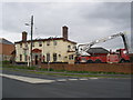
7

RIP "The Royal Oak", Exminster
Another once popular village pub appears to have met its unhappy end.
Image: © Neil Theasby
Taken: 28 Jun 2015
0.06 miles
8
The Royal Oak, Exminster, gutted by fire
The fire brigade monitor the building, following the massive fire, earlier today, in the early hours. This was the second major fire at this pub in the last six months.
Image: © Roger Cornfoot
Taken: 30 Mar 2009
0.06 miles
9
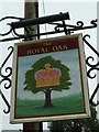
Orange Way in Devon and Torbay (202)
The "Royal Oak" PH is on Main Road in Exminster.
Image: © Shazz
Taken: 16 Nov 2011
0.06 miles
10
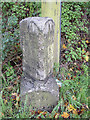
Old Milestone by the former A379, Exminster
Carved stone post by the former A379, in parish of EXMINSTER (TEIGNBRIDGE District), nearly opposite Jupes Close, 100m North of Royal Oak PH, on grass verge beside telegraph pole, on West side of road. Exeter granite facets, erected by the Exeter turnpike trust in the 19th century.
Inscription reads:-
: 4 / Miles to / Exeter / 8 / Miles to / Dawlish : : (180) / Miles to / (LONDON) : : 8 / Miles to / Dawlish / 4 / Miles to / Exeter :
Grade II listed. List Entry Number: 1097045
https://historicengland.org.uk/listing/the-list/list-entry/1097045
Milestone Society National ID: DV_EXTG04.
Image: © T Jenkinson
Taken: 29 Nov 2006
0.06 miles