IMAGES TAKEN NEAR TO
Belle Vue Close, EXETER, EX6 7UU
Introduction
This page details the photographs taken nearby to Belle Vue Close, EX6 7UU by members of the Geograph project.
The Geograph project started in 2005 with the aim of publishing, organising and preserving representative images for every square kilometre of Great Britain, Ireland and the Isle of Man.

There are currently over 7.5m images from over14,400 individuals and you can help contribute to the project by visiting https://www.geograph.org.uk
Image Map
Images are licensed for reuse under creativecommons.org/licenses/by-sa/2.0
Notes
- Clicking on the map will re-center to the selected point.
- The higher the marker number, the further away the image location is from the centre of the postcode.
Image Listing (60 Images Found)
Images are licensed for reuse under creativecommons.org/licenses/by-sa/2.0
Image
Details
Distance
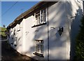
2
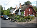
Forge and church, Kenn
The thatched Old Forge is at the lower end of the main village street; Image lies separately with a few other buildings beyond the River Kenn and its floodplain.
Image: © Derek Harper
Taken: 9 Oct 2007
0.06 miles
3
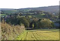
Kenn from the north
The village lies on the far side of the Kenn valley. Trehill is the white country house on the right. Beyond, the country rises to the Haldon ridge. In the foreground, Kenn Footpath 4 descends into the churchyard.
Image: © Derek Harper
Taken: 9 Oct 2007
0.06 miles
4
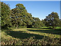
Field by the River Kenn
The tree on the right is at a junction of small drains which indicate the nature of the valley floor; the village is split on either side of it. The Kenn flows (very gently and away from the camera) amongst the trees on the left. Taken from the road into the village, a few yards southwest of the river bridge.
Image: © Derek Harper
Taken: 9 Oct 2007
0.10 miles
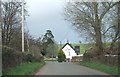
5
Kenn village
Approaching from the west.
Image: © Roger Cornfoot
Taken: 7 Sep 2008
0.12 miles

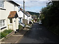
7

The Ley Arms, Kenn
The pub is at a lane junction close to the River Kenn - the wall in the foreground is the end of the bridge parapet. Not quite sure how much of the fabric remains from the C13, but it is an attractive traditional thatched building.
Image: © Derek Harper
Taken: 9 Oct 2007
0.13 miles
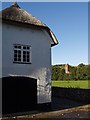
8
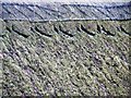
Thatch, Ley Arms, Kenn
The thatch of the Ley Arms seems to be providing a medium for some type of moss. The very damp weather has no doubt helped this process.
Image: © Tom Jolliffe
Taken: 14 Nov 2008
0.14 miles
9
The Ley Arms, Kenn
A close-up of Image The facade of the pub curves gently beside the junction of lanes to Kennford, Kenn and Kenton.
Image: © Derek Harper
Taken: 9 Oct 2007
0.14 miles
10
The Ley Arms Inn
The inn is beside the bridge over the River Kenn
Image: © David Smith
Taken: 27 Feb 2011
0.14 miles