IMAGES TAKEN NEAR TO
Bridford, EXETER, EX6 7HU
Introduction
This page details the photographs taken nearby to EX6 7HU by members of the Geograph project.
The Geograph project started in 2005 with the aim of publishing, organising and preserving representative images for every square kilometre of Great Britain, Ireland and the Isle of Man.

There are currently over 7.5m images from over14,400 individuals and you can help contribute to the project by visiting https://www.geograph.org.uk
Image Map
Images are licensed for reuse under creativecommons.org/licenses/by-sa/2.0
Notes
- Clicking on the map will re-center to the selected point.
- The higher the marker number, the further away the image location is from the centre of the postcode.
Image Listing (22 Images Found)
Images are licensed for reuse under creativecommons.org/licenses/by-sa/2.0
Image
Details
Distance
1
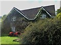
Lower Hole Farmhouse
Seen from the bridleway which runs through the farm.
Image: © Michael Dibb
Taken: 24 Sep 2018
0.00 miles
2
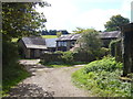
Lower Hole Farm accommodation
The farm offers holiday accommodation. Seen from the bridleway which runs through the farm.
Image: © Michael Dibb
Taken: 24 Sep 2018
0.03 miles
3
![Bridleways meet [3]](https://s2.geograph.org.uk/geophotos/05/93/04/5930494_31f0fc40_120x120.jpg)
Bridleways meet [3]
At the junction of the bridleways there are three ways to go. This is looking towards the wonderfully named Lower Hole and Bridford beyond.
Image: © Michael Dibb
Taken: 24 Sep 2018
0.08 miles
4
Hole, near Bridford
From the footpath from Hole to Poole Grove, looking across the lane to Lower Hole and the Beacon Plantation.
Image: © Derek Harper
Taken: 29 May 2006
0.09 miles
5
![Bridleways meet [1]](https://s0.geograph.org.uk/geophotos/05/93/04/5930492_f2a7fda5_120x120.jpg)
Bridleways meet [1]
At the junction of the bridleways there are three ways to go. This is looking towards the wonderfully named Middle Hole and the minor road beyond.
Image: © Michael Dibb
Taken: 24 Sep 2018
0.10 miles
6
Up the hill
After passing the wonderfully named Middle Hole, the bridleway ascends the hill towards its junction with another bridleway.
Image: © Michael Dibb
Taken: 24 Sep 2018
0.11 miles
7
![Bridleways meet [2]](https://s1.geograph.org.uk/geophotos/05/93/04/5930493_4e5107d7_120x120.jpg)
Bridleways meet [2]
At the junction of the bridleways there are three ways to go. This is looking towards Clampitt.
Image: © Michael Dibb
Taken: 24 Sep 2018
0.11 miles
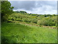
8
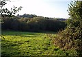
Field near Lower Hole
The view over the gate to the left referred to in Image Woodland seems to have encroached considerably into this field, which slopes to the small stream that runs between the three farms at Hole. The woodland beyond is around Little Tor.
Image: © Derek Harper
Taken: 5 Oct 2007
0.12 miles
9
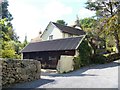
Middle Hole
The thatched house visible behind the cottage converted from a barn is a 17th century former farmhouse. Listed, grade II, with details at: https://historicengland.org.uk/listing/the-list/list-entry/1097823 Seen from the bridleway.
Image: © Michael Dibb
Taken: 24 Sep 2018
0.12 miles
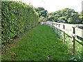
10
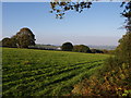
Field near Higher Hole
A view from Bridford Bridleway 49 as it approaches the farms at Hole.
Image: © Derek Harper
Taken: 5 Oct 2007
0.14 miles