IMAGES TAKEN NEAR TO
Longdown, EXETER, EX6 7BB
Introduction
This page details the photographs taken nearby to EX6 7BB by members of the Geograph project.
The Geograph project started in 2005 with the aim of publishing, organising and preserving representative images for every square kilometre of Great Britain, Ireland and the Isle of Man.

There are currently over 7.5m images from over14,400 individuals and you can help contribute to the project by visiting https://www.geograph.org.uk
Image Map
Images are licensed for reuse under creativecommons.org/licenses/by-sa/2.0
Notes
- Clicking on the map will re-center to the selected point.
- The higher the marker number, the further away the image location is from the centre of the postcode.
Image Listing (13 Images Found)
Images are licensed for reuse under creativecommons.org/licenses/by-sa/2.0
Image
Details
Distance

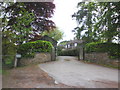


5

Road past farm entrance on Perridge Estate
Image: © David Gearing
Taken: 20 Sep 2013
0.04 miles
6
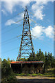
Barn and pylon, Darnaford
On the edge of Brockham Plantation.
Image: © Derek Harper
Taken: 25 Sep 2018
0.06 miles
7
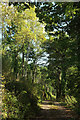
Track through Brockham Plantation
The private track is seen from beside Image
Image: © Derek Harper
Taken: 25 Sep 2018
0.07 miles
8

Haldon Hills at Darnaford
The northern slopes of the Haldon Hills, alternately woodland and pasture, are here bisected by what is, in effect, the upper valley of the River Kenn.
Image: © Derek Harper
Taken: 27 Apr 2006
0.13 miles
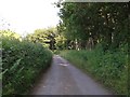
9

Lane approaching Darnaford
The lane emerges from woodland on the right.
Image: © Derek Harper
Taken: 25 Sep 2018
0.15 miles
10
Lane heading along the edge of Knowle Plantation
Image: © Rob Purvis
Taken: 9 Jul 2013
0.17 miles