IMAGES TAKEN NEAR TO
Hittisleigh, EXETER, EX6 6LF
Introduction
This page details the photographs taken nearby to EX6 6LF by members of the Geograph project.
The Geograph project started in 2005 with the aim of publishing, organising and preserving representative images for every square kilometre of Great Britain, Ireland and the Isle of Man.

There are currently over 7.5m images from over14,400 individuals and you can help contribute to the project by visiting https://www.geograph.org.uk
Image Map
Images are licensed for reuse under creativecommons.org/licenses/by-sa/2.0
Notes
- Clicking on the map will re-center to the selected point.
- The higher the marker number, the further away the image location is from the centre of the postcode.
Image Listing (13 Images Found)
Images are licensed for reuse under creativecommons.org/licenses/by-sa/2.0
Image
Details
Distance
1

Hittisleigh Barton
The farmhouse, to the right of the barn, has C16 origins http://list.english-heritage.org.uk/resultsingle.aspx?uid=1258508&searchtype=mapsearch . Behind it can be seen the tower of the church.
Image: © Derek Harper
Taken: 10 Mar 2015
0.02 miles
3
Side chapel, St. Andrew's, Hittisleigh, Devon
Image: © nick macneill
Taken: 14 Mar 1996
0.03 miles
5

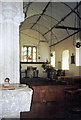
Font, Hittisleigh
The Norman font in Image is of Purbeck stone, square on a cylindrical shaft, with a crude zig-zag decoration.
Image: © Derek Harper
Taken: 1 Mar 2010
0.03 miles
6

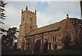
St Andrew's Church, Hittisleigh
Another view of http://www.geograph.org.uk/search.php?i=11144718 from across the churchyard. Cherry & Pevsner call it "a simple church of Dartmoor character". As a major feature on this stretch of the Two Moors Way the church is much frequented by walkers. There is a very thorough architectural description at http://www.imagesofengland.org.uk/Details/Default.aspx?id=445091&mode=adv .
Image: © Derek Harper
Taken: 1 Mar 2010
0.03 miles
7
Hittisleigh: St Andrew?s church
Off the beaten track, by Hittisleigh Barton
Image: © Martin Bodman
Taken: 1 Oct 2008
0.03 miles
8
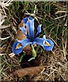
Iris, Hittisleigh
This pretty blue and yellow miniature iris was in the churchyard of Image
Image: © Derek Harper
Taken: 1 Mar 2010
0.03 miles
9

Ordnance Survey Cut Mark
This OS cut mark can be found on the NW face of St Andrew's Church. It marks a point 203.646m above mean sea level.
Image: © Adrian Dust
Taken: 31 Mar 2019
0.04 miles
10

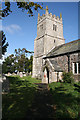
St Andrew's Church, Hittisleigh Barton
Image: © David Gearing
Taken: 27 Apr 2015
0.04 miles