IMAGES TAKEN NEAR TO
Roman Way, EXETER, EX5 7BU
Introduction
This page details the photographs taken nearby to Roman Way, EX5 7BU by members of the Geograph project.
The Geograph project started in 2005 with the aim of publishing, organising and preserving representative images for every square kilometre of Great Britain, Ireland and the Isle of Man.

There are currently over 7.5m images from over14,400 individuals and you can help contribute to the project by visiting https://www.geograph.org.uk
Image Map
Images are licensed for reuse under creativecommons.org/licenses/by-sa/2.0
Notes
- Clicking on the map will re-center to the selected point.
- The higher the marker number, the further away the image location is from the centre of the postcode.
Image Listing (58 Images Found)
Images are licensed for reuse under creativecommons.org/licenses/by-sa/2.0
Image
Details
Distance
1
Cycle way and footpath on edge of Cranbrook, by B3174 (5)
Image: © David Smith
Taken: 11 Jul 2020
0.02 miles
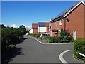
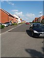
2
Cranbrook : Copseclose Road
A new development and housing estate in Cranbrook.
Image: © Lewis Clarke
Taken: 4 Aug 2015
0.06 miles
3

Cranbrook: Gratton Park
Off Mayfield Way. Part of the new town development begun circa 2013
Image: © Martin Bodman
Taken: 23 May 2018
0.07 miles
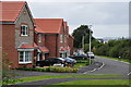
4
Cranbrook : London Road, B3174
Looking along London Road as it heads alongside the new development.
Image: © Lewis Clarke
Taken: 4 Aug 2015
0.07 miles
5
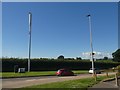
Communications mast, B3174, opposite St Michael's Way, Cranbrook
Image: © David Smith
Taken: 11 Jul 2020
0.07 miles
6
Cranbrook: Mayfield Way
A street in Cranbrook new town development
Image: © Martin Bodman
Taken: 23 May 2018
0.08 miles
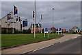
7

Cranbrook : Roundabout
A roundabout between London Road and Mayfield Way.
Image: © Lewis Clarke
Taken: 4 Aug 2015
0.08 miles
9

Cranbrook: Mayfield Way
On the southern edge of the new town, with much more housing to come
Image: © Martin Bodman
Taken: 23 May 2018
0.08 miles
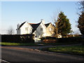
10

House at the end of St Michael's Way, Cranbrook
Image: © David Smith
Taken: 11 Jul 2020
0.08 miles