IMAGES TAKEN NEAR TO
Bullen Close, EXETER, EX5 5NW
Introduction
This page details the photographs taken nearby to Bullen Close, EX5 5NW by members of the Geograph project.
The Geograph project started in 2005 with the aim of publishing, organising and preserving representative images for every square kilometre of Great Britain, Ireland and the Isle of Man.

There are currently over 7.5m images from over14,400 individuals and you can help contribute to the project by visiting https://www.geograph.org.uk
Image Map
Images are licensed for reuse under creativecommons.org/licenses/by-sa/2.0
Notes
- Clicking on the map will re-center to the selected point.
- The higher the marker number, the further away the image location is from the centre of the postcode.
Image Listing (97 Images Found)
Images are licensed for reuse under creativecommons.org/licenses/by-sa/2.0
Image
Details
Distance
2
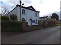
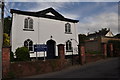
Thorverton Baptist Church
This neat building at the top of the village dates from 1833-34 http://www.imagesofengland.org.uk/Details/Default.aspx?id=439559&mode=adv .
Image: © Derek Harper
Taken: 4 May 2010
0.03 miles
3
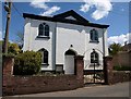
Thorverton : Baptist Church
There is a Baptist church on Berrysbridge Road built in 1832 by the Baptists that lived in Thorverton, with John Hockin preaching the first sermons. They began with steep standards. In 1833, Mary Squire had her membership revoked due to her 'improper walk and conduct'. Another, Mrs Harris, for 'unchristian spirit' in 1837. A Roman Catholic Chapel was located in the hamlet of Raddon, but by 1850 this had become part of a farmhouse called Chapel St. Martin.
Image: © Lewis Clarke
Taken: 21 Jun 2015
0.03 miles
4

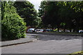
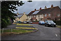
Entering Thorverton
The road from Berrysbridge passes a couple of modern closes - Broadlands to the left and The Glebe to the right - before dropping into the older part of the village. It is at the nearer junction that the bus turns round.
Image: © Derek Harper
Taken: 4 May 2010
0.04 miles
5
Thorverton : Broadlands
A small residential road on the Thorverton outskirts.
Image: © Lewis Clarke
Taken: 21 Jun 2015
0.05 miles
6
Thorverton : Cleaves Close
Cleaves Close is a small residential road in Thorverton.
Image: © Lewis Clarke
Taken: 21 Jun 2015
0.05 miles
7
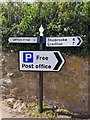
Direction Sign ? Signpost
Located on the northwest side of the junction of Bullen Street and Lynch Road in Thorverton parish. 2 arms, 1 worboys, and onion finial. For older photos see https://www.geograph.org.uk/photo/6061227 and http://www.flickr.com/photos/bridgemarkertim/5086125573/.
Milestone Society National ID: DV_SS9202
Image: © N Savage
Taken: 13 Apr 2020
0.06 miles
8
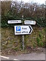
Old Direction Sign - Signpost by Bullen STreet, Thorverton
Onion finial - 2 arms, 1 Worboys; Devon simple by the UC road, in parish of Thorverton (Mid Devon District), Bullen Street junction with Dark Lane, by stone wall.
Surveyed
Milestone Society National ID: DV_SS9202
Image: © Alan Rosevear
Taken: 7 Feb 2013
0.06 miles
9
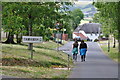
Thorverton : Village Road & Sign
The name of Thorverton may be Scandinavian in origin and the village might have been named after its founder. Old records mention the parish as Toruerton in 1182. In 1340 the parish was called Thorferton. Other sources believe that the name is an ancient reference to a thorn-bush besides a river crossing.
Image: © Lewis Clarke
Taken: 21 Jun 2015
0.07 miles
10
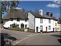
Cottages, Thorverton
See Image, which also shows the thatched cottage on the left. Bullen Street heads down to the right towards the centre of the village.
Image: © Derek Harper
Taken: 4 May 2010
0.07 miles