IMAGES TAKEN NEAR TO
Thorverton, EXETER, EX5 5NS
Introduction
This page details the photographs taken nearby to EX5 5NS by members of the Geograph project.
The Geograph project started in 2005 with the aim of publishing, organising and preserving representative images for every square kilometre of Great Britain, Ireland and the Isle of Man.

There are currently over 7.5m images from over14,400 individuals and you can help contribute to the project by visiting https://www.geograph.org.uk
Image Map
Images are licensed for reuse under creativecommons.org/licenses/by-sa/2.0
Notes
- Clicking on the map will re-center to the selected point.
- The higher the marker number, the further away the image location is from the centre of the postcode.
Image Listing (108 Images Found)
Images are licensed for reuse under creativecommons.org/licenses/by-sa/2.0
Image
Details
Distance
1
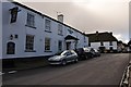
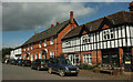
Thorverton : Bullen Street
Bullen Street and the Thorverton Arms can be seen here.
Image: © Lewis Clarke
Taken: 16 Sep 2013
0.00 miles
2
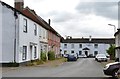
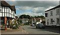
The Bury, Thorverton, Devon
Looking South towards the Thorverton Arms in Bullen Street
Image: © Derek Voller
Taken: 15 Jun 2014
0.01 miles
3
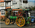
Full stream ahead, Thorverton
The traction engine shown in Image] climbs through the centre of the village.
Image: © Derek Harper
Taken: 18 Sep 2022
0.01 miles
4
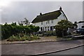
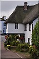
Thorverton : Acorn Cottage
GV II House and adjoining cottage, formerly 1 build. Probably C18, C20 renovations. Unusual materials of construction : a photograph of the front elevation of Acorn Cottage with the render stripped off shows local stone rubble up to approximately first floor level, this acts as a plinth for a frame of timber studs infilled with cob bricks; the rest of the range may be constructed in the same way; Acorn Cottage has an internal framed partition wall, with cob brick infill and part, at least, of the axial stack of Acorn House is also of cob bricks.
Image: © Lewis Clarke
Taken: 16 Sep 2013
0.02 miles
5
The Bury, Thorverton
Alas, not as car-free as when Roger visited Image Viewed from the junction with Bullen Street. On the right is a general stores.
Image: © Derek Harper
Taken: 18 Sep 2022
0.02 miles
6
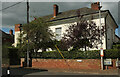
Berry House, Thorverton
On Bullen Street at its junction with The Bury (right). The house is listed https://historicengland.org.uk/listing/the-list/list-entry/1240387?section=official-list-entry .
Image: © Derek Harper
Taken: 18 Sep 2022
0.02 miles
7
Thorverton village centre
Looking right from Image], with the general stores on the corner of The Bury on the left. On the other side of Bullen Street is the Thorverton Arms. The main street then becomes Silver Street, swinging right at the Jubilee green where it meets the Exe Valley Way.
Image: © Derek Harper
Taken: 18 Sep 2022
0.02 miles
8
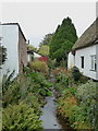
Stream running between the houses in Thorverton
An un-named tributary of the Exe.
Image: © Rod Allday
Taken: 27 Oct 2016
0.03 miles
9
Thorverton : Bridge House
Bridge House, with its picturesque front elevation is in a crucial position in the centre of Thorverton.
Image: © Lewis Clarke
Taken: 16 Sep 2013
0.03 miles
10
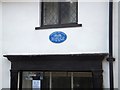
Plaque on former post office in Thorverton
The plaque shows how three members of one family served as postmasters for over a century
Image: © David Smith
Taken: 14 Feb 2013
0.03 miles