IMAGES TAKEN NEAR TO
Cowley, EXETER, EX5 5DG
Introduction
This page details the photographs taken nearby to EX5 5DG by members of the Geograph project.
The Geograph project started in 2005 with the aim of publishing, organising and preserving representative images for every square kilometre of Great Britain, Ireland and the Isle of Man.

There are currently over 7.5m images from over14,400 individuals and you can help contribute to the project by visiting https://www.geograph.org.uk
Image Map
Images are licensed for reuse under creativecommons.org/licenses/by-sa/2.0
Notes
- Clicking on the map will re-center to the selected point.
- The higher the marker number, the further away the image location is from the centre of the postcode.
Image Listing (70 Images Found)
Images are licensed for reuse under creativecommons.org/licenses/by-sa/2.0
Image
Details
Distance
1
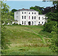
Cowley House, Cowley
A fine house distinguished by a pair of full-height bows. It was built c1778 for William Jackson to the designs of his father, also William. Grade II listed.
Now flats.
Image: © Stephen Richards
Taken: 20 Jun 2014
0.01 miles
2
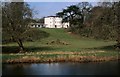
Cowley House, 2000
Listed as Cowley House https://www.historicengland.org.uk/listing/the-list/list-entry/1164175 , mapped as Cowley Place. Virtually identical to the views at http://www.geograph.org.uk/search.php?i=78323945 . This is taken from Cowley Bridge and, more serious than any debate about the name of the house, the identity of the river in view is in doubt. A glance at the map would suggest that it is the River Exe, just downstream from its confluence with the River Creedy, and this is backed up by the listed building description for the bridge : "road bridge across the River Exe", but detailed OS maps identify it as the River Creedy.
Image: © Derek Harper
Taken: Unknown
0.01 miles
3

Upton Pyne: house at Cowley
Seen from Cowley Bridge on the Crediton road, overlooking the river Exe, just below its confluence with the Creedy
Image: © Martin Bodman
Taken: 27 Oct 2007
0.02 miles
4
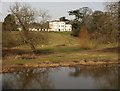
Cowley House
Or Cowley Place, and in a fine setting looking down to the River Creedy. The country house, with its two full-height bows, dates from the late C18 http://www.imagesofengland.org.uk/Details/Default.aspx?id=86111&mode=adv .
Image: © Derek Harper
Taken: 2 Mar 2010
0.02 miles
5

Cowley House
Cowley House is a late 18th century mansion.
Image: © Tony Atkin
Taken: 11 May 2014
0.02 miles
6

Bellcote, Cowley
A closer view of the bellcote of Image, described at http://www.imagesofengland.org.uk/Details/Default.aspx?id=86115&mode=adv as having a "steeply pitched stone pyramidal cap carved on four stubby shafts with foliated capitals". According to the listed building description, only two of architect Rhode Hawkins' churches survive - the other is Image
Image: © Derek Harper
Taken: 2 Mar 2010
0.04 miles
7
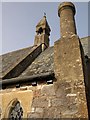
St Leonard's Chapel, Cowley
Showing the bellcote and other details of this chapel of ease, dating from 1867-8 http://www.imagesofengland.org.uk/Details/Default.aspx?id=86115&mode=adv . See also http://www.geograph.org.uk/gridref/SX9095?centi=SX905956 .
Image: © Derek Harper
Taken: 2 Mar 2010
0.04 miles
8
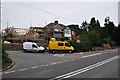
Cowley : Cowley Hill A377
Cowley Hill at the road junction with St Andrew's Road.
Image: © Lewis Clarke
Taken: 21 Sep 2012
0.05 miles
9

Carved head, St Leonard's Chapel, Cowley
A face that somehow seems to possess considerable wisdom, acting as a label stop on the south side of Image
Image: © Derek Harper
Taken: 2 Mar 2010
0.05 miles
10
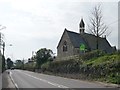
Church for sale, Cowley
St Anthony's was built in 1867/8 and is Grade 2 listed. Yours for around £150,000. See http://www.churchofengland.org/clergy-office-holders/pastoralandclosedchurches/closedchurches/closed-churches-available/cowley.aspx for more details.
Image: © Christine Johnstone
Taken: 29 Mar 2014
0.05 miles