IMAGES TAKEN NEAR TO
Bradninch, EXETER, EX5 4NA
Introduction
This page details the photographs taken nearby to EX5 4NA by members of the Geograph project.
The Geograph project started in 2005 with the aim of publishing, organising and preserving representative images for every square kilometre of Great Britain, Ireland and the Isle of Man.

There are currently over 7.5m images from over14,400 individuals and you can help contribute to the project by visiting https://www.geograph.org.uk
Image Map
Images are licensed for reuse under creativecommons.org/licenses/by-sa/2.0
Notes
- Clicking on the map will re-center to the selected point.
- The higher the marker number, the further away the image location is from the centre of the postcode.
Image Listing (20 Images Found)
Images are licensed for reuse under creativecommons.org/licenses/by-sa/2.0
Image
Details
Distance
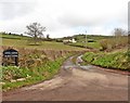
1
Valley of small stream at Coombe
The road dips into the valley. Beyond the trees is Moorhaven (house)
Image: © David Smith
Taken: 27 Dec 2011
0.04 miles
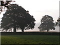
2
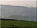
Fields near Bradninch, Hele Mill in background
Image: © Rob Purvis
Taken: 16 Sep 2008
0.06 miles
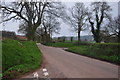
3
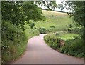
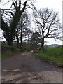
Road to Bradninch
The road from Silverton crosses the Coombe valley, swinging part the entrance to farms on the left.
Image: © Derek Harper
Taken: 23 Jul 2010
0.06 miles
4
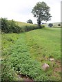
Watercourse below Coombe
Seen from the stretch of road shown in Image The watercourse, lmost full of watercress, has been channelled along the side rather than the foot of the valley, creating a leat, presumably as part of a watering system.
Image: © Derek Harper
Taken: 23 Jul 2010
0.06 miles
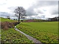
6
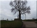
Access road to Lower and Higher Coombe
Image: © Roger Cornfoot
Taken: 28 Mar 2018
0.08 miles
8
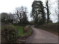
Mid Devon : Country Lane
A country lane which heads in the direction of Bradninch.
Image: © Lewis Clarke
Taken: 29 Mar 2014
0.13 miles