IMAGES TAKEN NEAR TO
Broadclyst, EXETER, EX5 3LH
Introduction
This page details the photographs taken nearby to EX5 3LH by members of the Geograph project.
The Geograph project started in 2005 with the aim of publishing, organising and preserving representative images for every square kilometre of Great Britain, Ireland and the Isle of Man.

There are currently over 7.5m images from over14,400 individuals and you can help contribute to the project by visiting https://www.geograph.org.uk
Image Map
Images are licensed for reuse under creativecommons.org/licenses/by-sa/2.0
Notes
- Clicking on the map will re-center to the selected point.
- The higher the marker number, the further away the image location is from the centre of the postcode.
Image Listing (8 Images Found)
Images are licensed for reuse under creativecommons.org/licenses/by-sa/2.0
Image
Details
Distance
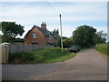
2
Cutton Cottages seen from Danes Wood
On the skyline is Woodbury Castle
Image: © David Smith
Taken: 1 Nov 2009
0.04 miles
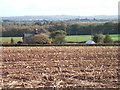
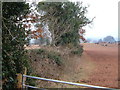
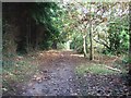
3
Field boundary by Danes Wood
From the edge of Danes Wood, which is access woodland.
Image: © Derek Harper
Taken: 23 Mar 2006
0.11 miles
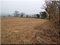
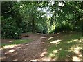
4
Field boundary by Danes Wood
Showing the point where the field boundary seen in Image], with cattle revealed in the adjoining field, getting some winter fodder.
Image: © Derek Harper
Taken: 23 Mar 2006
0.11 miles
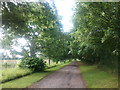
7
Danes Hill
The road climbs past Danes Wood on the right; the second patch of sun on the right of the road indicates the entrance to the car park.
Image: © Derek Harper
Taken: 1 Jul 2009
0.23 miles
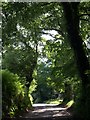
8
Danes Wood
A path, just northeast of the car park, through the popular stretch of access woodland.
Image: © Derek Harper
Taken: 1 Jul 2009
0.25 miles