IMAGES TAKEN NEAR TO
Broadclyst, EXETER, EX5 3DR
Introduction
This page details the photographs taken nearby to EX5 3DR by members of the Geograph project.
The Geograph project started in 2005 with the aim of publishing, organising and preserving representative images for every square kilometre of Great Britain, Ireland and the Isle of Man.

There are currently over 7.5m images from over14,400 individuals and you can help contribute to the project by visiting https://www.geograph.org.uk
Image Map
Images are licensed for reuse under creativecommons.org/licenses/by-sa/2.0
Notes
- Clicking on the map will re-center to the selected point.
- The higher the marker number, the further away the image location is from the centre of the postcode.
Image Listing (10 Images Found)
Images are licensed for reuse under creativecommons.org/licenses/by-sa/2.0
Image
Details
Distance
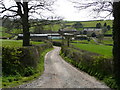
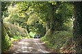
2
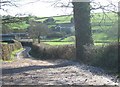
Road to Beare from Frogmore
Just to the north-west of Lower Comberoy Farm, the road enters a small wood
Image: © David Smith
Taken: 19 Feb 2011
0.08 miles
4
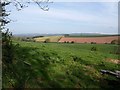
Valleys below Frogmore Farm
A view over the gate shown on the right of Image Two small valleys meet; the treetop to the right indicates the nearer one, below Frogmore Farm. Across the further one, scattered trees line the lane down to the B3181 at Beare.
Image: © Derek Harper
Taken: 13 May 2010
0.10 miles
5
Lower Comberoy Farm
Nestled in a side valley of the Culm.
Image: © Jonathan Billinger
Taken: 1 Apr 2008
0.10 miles
6
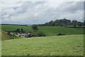
Broadclyst: towards Lower Comberoy Farm
With the hill known as Killerton Park on the skyline. Lower Comberoy Farm forms part of the National Trust's Killerton estate, land that previously belonged to the Acland family
Image: © Martin Bodman
Taken: 25 Oct 2011
0.16 miles
7
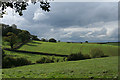
Broadclyst: above Lower Comberoy Farm
With cloud building: heavy rain followed in a couple of hours. In Broadclyst parish
Image: © Martin Bodman
Taken: 25 Oct 2011
0.22 miles
8
Broadclyst: north from Lower Comberoy
A lane leading to the B3181 Cullompton – Exeter road, a little to the north of the site of a holy well. Looking north; to the west a valley runs down to Beare
Image: © Martin Bodman
Taken: 29 Jan 2006
0.24 miles
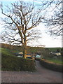
9

Broadclyst: lane near Frogmore Farm
Looking south east; the lane leads to Frogmore Cross
Image: © Martin Bodman
Taken: 20 Nov 2005
0.24 miles
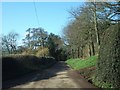
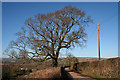
10
Broadclyst: below Frogmore Cross
On the lane from Beare
Image: © Martin Bodman
Taken: 25 Oct 2011
0.25 miles