IMAGES TAKEN NEAR TO
Broadclyst, EXETER, EX5 3BY
Introduction
This page details the photographs taken nearby to EX5 3BY by members of the Geograph project.
The Geograph project started in 2005 with the aim of publishing, organising and preserving representative images for every square kilometre of Great Britain, Ireland and the Isle of Man.

There are currently over 7.5m images from over14,400 individuals and you can help contribute to the project by visiting https://www.geograph.org.uk
Image Map
Images are licensed for reuse under creativecommons.org/licenses/by-sa/2.0
Notes
- Clicking on the map will re-center to the selected point.
- The higher the marker number, the further away the image location is from the centre of the postcode.
Image Listing (3 Images Found)
Images are licensed for reuse under creativecommons.org/licenses/by-sa/2.0
Image
Details
Distance
3
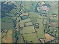
Countryside around Burrow from the air
The River Clyst crosses the left half of the image towards the camera; the further part of this course, running below Ashclyst Forest, is in Image Until it reaches a level with Chillacombe Farm (lower left), it is in Image
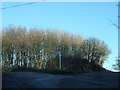
The fork in the road is at Forches Head. Above right is Exeter electricity substation - see Image
Seen from a hot air balloon.
Image: © Derek Harper
Taken: 1 Jul 2009
0.10 miles