IMAGES TAKEN NEAR TO
Cobden Lane, EXETER, EX5 2PZ
Introduction
This page details the photographs taken nearby to Cobden Lane, EX5 2PZ by members of the Geograph project.
The Geograph project started in 2005 with the aim of publishing, organising and preserving representative images for every square kilometre of Great Britain, Ireland and the Isle of Man.

There are currently over 7.5m images from over14,400 individuals and you can help contribute to the project by visiting https://www.geograph.org.uk
Image Map
Images are licensed for reuse under creativecommons.org/licenses/by-sa/2.0
Notes
- Clicking on the map will re-center to the selected point.
- The higher the marker number, the further away the image location is from the centre of the postcode.
Image Listing (7 Images Found)
Images are licensed for reuse under creativecommons.org/licenses/by-sa/2.0
Image
Details
Distance
2
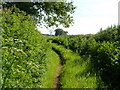
A lane with public access near Whimple
This green lane cuts off a corner of the minor road from Higher Cobden to Whimple, and passes through field lanes; there are no signs at its ends that there is public access, but it is marked as such on the OS map.
Image: © David Smith
Taken: 18 Sep 2011
0.14 miles
3
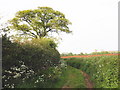
Strawberry Lane, Cobden
This green lane provides a short cut to Whimple; taken a few yards along from the lane near Higher Cobden.
Image: © Derek Harper
Taken: 1 Jun 2006
0.14 miles
5
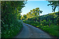
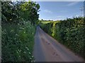
East Devon : Country Lane
A small lane heading through East Devon.
Image: © Lewis Clarke
Taken: 13 May 2018
0.20 miles
6
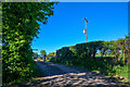
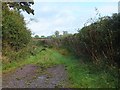
East Devon : Track
A small track to Little Cobden.
Image: © Lewis Clarke
Taken: 13 May 2018
0.20 miles
7
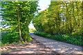
East Devon : Country Lane
A small lane heading through the East Devon countryside.
Image: © Lewis Clarke
Taken: 13 May 2018
0.21 miles