IMAGES TAKEN NEAR TO
The Paddock, EXETER, EX5 2NP
Introduction
This page details the photographs taken nearby to The Paddock, EX5 2NP by members of the Geograph project.
The Geograph project started in 2005 with the aim of publishing, organising and preserving representative images for every square kilometre of Great Britain, Ireland and the Isle of Man.

There are currently over 7.5m images from over14,400 individuals and you can help contribute to the project by visiting https://www.geograph.org.uk
Image Map
Images are licensed for reuse under creativecommons.org/licenses/by-sa/2.0
Notes
- Clicking on the map will re-center to the selected point.
- The higher the marker number, the further away the image location is from the centre of the postcode.
Image Listing (9 Images Found)
Images are licensed for reuse under creativecommons.org/licenses/by-sa/2.0
Image
Details
Distance
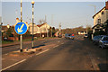
1

The Paddock
Small housing development by the B3174 road
Image: © Martin Bodman
Taken: 20 May 2018
0.02 miles
2

The B3174 east of the Hand and Pen
The road can be seen to swing south-eastwards, heading towards and climbing up to Straightway Head Big Wood. But 2,000 years ago the Roman road ran straight on
Image: © Martin Bodman
Taken: 20 May 2018
0.07 miles
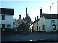
3
Hand and Pen the old A30
Looking East by the Whimple turn off .
Image: © roger geach
Taken: 6 Mar 2011
0.21 miles

5
Minor road going south from Hand and Pen
The Hand and Pen crossroads is where the former A30 has a junction with the road to Whimple and a minor road to the south.
Image: © David Smith
Taken: 20 Jan 2011
0.22 miles
6

East Devon : Church Road
Looking along Church Road.
Image: © Lewis Clarke
Taken: 13 May 2018
0.24 miles
7
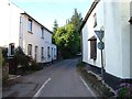
Lane to Strete Ralegh
Image: © Derek Harper
Taken: 2 Jun 2006
0.24 miles

9
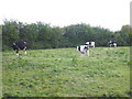
Dairy cattle, grazing at Pithayes Farm
Image: © Roger Cornfoot
Taken: 18 May 2010
0.25 miles