IMAGES TAKEN NEAR TO
Clyst Honiton, EXETER, EX5 2HN
Introduction
This page details the photographs taken nearby to EX5 2HN by members of the Geograph project.
The Geograph project started in 2005 with the aim of publishing, organising and preserving representative images for every square kilometre of Great Britain, Ireland and the Isle of Man.

There are currently over 7.5m images from over14,400 individuals and you can help contribute to the project by visiting https://www.geograph.org.uk
Image Map
Images are licensed for reuse under creativecommons.org/licenses/by-sa/2.0
Notes
- Clicking on the map will re-center to the selected point.
- The higher the marker number, the further away the image location is from the centre of the postcode.
Image Listing (43 Images Found)
Images are licensed for reuse under creativecommons.org/licenses/by-sa/2.0
Image
Details
Distance
1
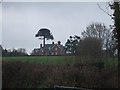
Marlborough Farm
The trees in the farmhouse garden include the Monkey Puzzle
Image: © David Smith
Taken: 18 Feb 2011
0.02 miles

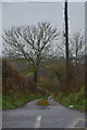
3
East Devon : Country Lane
A small country lane in East Devon.
Image: © Lewis Clarke
Taken: 14 Mar 2018
0.04 miles

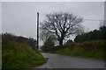
6
East Devon : Marlborough Cross
A road in the East Devon countryside.
Image: © Lewis Clarke
Taken: 14 Mar 2018
0.05 miles
7
East Devon : Country Lane
Looking along a small country lane.
Image: © Lewis Clarke
Taken: 14 Mar 2018
0.05 miles
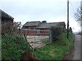
8
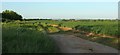
Field by Marlborough Farm
A track from the lane between Marlborough Cross and Holbrook enters this field; airport buildings can be seen in the distance.
Image: © Derek Harper
Taken: 16 May 2016
0.06 miles
9

East Devon : Marlborough Cross
A road seen at Marlborough Cross.
Image: © Lewis Clarke
Taken: 14 Mar 2018
0.06 miles
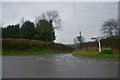
10
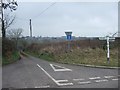
Marlborough Cross
The lane ahead became a cul-de-sac with the construction of the A30 dual carriageway. It originally led to Clyst Honiton.
Image: © David Smith
Taken: 18 Feb 2011
0.07 miles