IMAGES TAKEN NEAR TO
Village Way, EXETER, EX5 2FD
Introduction
This page details the photographs taken nearby to Village Way, EX5 2FD by members of the Geograph project.
The Geograph project started in 2005 with the aim of publishing, organising and preserving representative images for every square kilometre of Great Britain, Ireland and the Isle of Man.

There are currently over 7.5m images from over14,400 individuals and you can help contribute to the project by visiting https://www.geograph.org.uk
Image Map
Images are licensed for reuse under creativecommons.org/licenses/by-sa/2.0
Notes
- Clicking on the map will re-center to the selected point.
- The higher the marker number, the further away the image location is from the centre of the postcode.
Image Listing (21 Images Found)
Images are licensed for reuse under creativecommons.org/licenses/by-sa/2.0
Image
Details
Distance
1
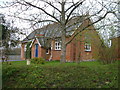
Bendarroch School, Aylesbeare
A tiny independent school on the southern edge of the village, seen from the south-west.
Image: © Derek Harper
Taken: 18 Apr 2006
0.04 miles
2

You are now entering Aylesbeare
Looking North West.
Image: © Anthony Vosper
Taken: 24 Oct 2010
0.05 miles
3
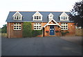
Bendarroch School for girls, Aylesbeare
Image: © Roger Cornfoot
Taken: 9 Jul 2009
0.06 miles
4

The Chestnuts
New infill housing taking its name from the nearby trees.
Image: © Anthony Vosper
Taken: 24 Oct 2010
0.06 miles
5
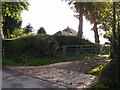
Footpath to Randlehayes Farm
Over the stile or through the gate will take you across the fields to the farm.
Image: © Anthony Vosper
Taken: 24 Oct 2010
0.07 miles

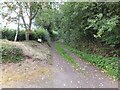
7
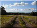
Extra access
This well defined trackway does not appear on the map provides access across various fields.
Image: © Anthony Vosper
Taken: 24 Oct 2010
0.07 miles
8

The end of a public footpath in Aylesbeare
The path leads to Randlehayes Farm and follows a track from there to the houses at Nutwalls.
Image: © David Smith
Taken: 1 Aug 2011
0.10 miles
9

Footpath to Randlehayes Farm
One of a number of pathways around the village.
Image: © Anthony Vosper
Taken: 24 Oct 2010
0.12 miles
10
Blind Lane, Aylesbeare
Users of the lane are greeted with a succession of signs. First: Unmetalled Road; then: Unsuitable for Vehicles; then: County Road. It is a rough track, with an eroded surface, leading to woods on the east of the village.
Image: © David Smith
Taken: 1 Aug 2011
0.13 miles