IMAGES TAKEN NEAR TO
Toby Lane, EXETER, EX5 1QB
Introduction
This page details the photographs taken nearby to Toby Lane, EX5 1QB by members of the Geograph project.
The Geograph project started in 2005 with the aim of publishing, organising and preserving representative images for every square kilometre of Great Britain, Ireland and the Isle of Man.

There are currently over 7.5m images from over14,400 individuals and you can help contribute to the project by visiting https://www.geograph.org.uk
Image Map
Images are licensed for reuse under creativecommons.org/licenses/by-sa/2.0
Notes
- Clicking on the map will re-center to the selected point.
- The higher the marker number, the further away the image location is from the centre of the postcode.
Image Listing (18 Images Found)
Images are licensed for reuse under creativecommons.org/licenses/by-sa/2.0
Image
Details
Distance
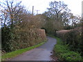
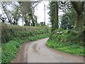
2
Dog Lane
Evening sun along the lane from Woodbury Park to Woodbury Salterton.
Image: © Derek Harper
Taken: 15 May 2016
0.11 miles
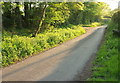
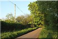
5
The road to Woodbury Salterton from Oak Well
Image: © David Smith
Taken: 5 Apr 2011
0.12 miles
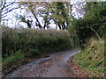
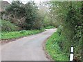
6
Dog Lane
Looking in the opposite direction from the same spot as Image
Image: © Derek Harper
Taken: 15 May 2016
0.13 miles
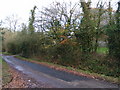
9
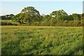
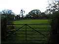
Field, Little Coombe
The lush May countryside seen from Dog Lane.
Image: © Derek Harper
Taken: 15 May 2016
0.15 miles
10
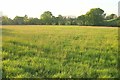
Field, Little Coombe
The lush meadow shown in Image], looking more to the left. A tiny tributary of the Grindle Brook runs along the far side past the trees.
Image: © Derek Harper
Taken: 15 May 2016
0.15 miles