IMAGES TAKEN NEAR TO
Clyst St. Mary, EXETER, EX5 1BG
Introduction
This page details the photographs taken nearby to EX5 1BG by members of the Geograph project.
The Geograph project started in 2005 with the aim of publishing, organising and preserving representative images for every square kilometre of Great Britain, Ireland and the Isle of Man.

There are currently over 7.5m images from over14,400 individuals and you can help contribute to the project by visiting https://www.geograph.org.uk
Image Map
Images are licensed for reuse under creativecommons.org/licenses/by-sa/2.0
Notes
- Clicking on the map will re-center to the selected point.
- The higher the marker number, the further away the image location is from the centre of the postcode.
Image Listing (84 Images Found)
Images are licensed for reuse under creativecommons.org/licenses/by-sa/2.0
Image
Details
Distance
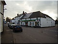
3

The Maltsters
One of two pubs in the village both owned by the same brewery chain.
Image: © Anthony Vosper
Taken: 8 Feb 2010
0.04 miles
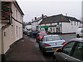
4
The village stores
What once was a row of shops and a Post office has now merged to come a small supermarket.
Image: © Anthony Vosper
Taken: 8 Feb 2010
0.04 miles
5
Clyst St Mary Roundabout
Viewed from the footbridge across the A3052.
Sandy park, home of Exeter Chiefs rugby team features on the horizon.
Image: © Anthony Vosper
Taken: 11 Jun 2012
0.05 miles
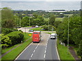
6
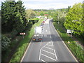
A3052 approaching roundabout
At junction with A376.
Image: © Peter Holmes
Taken: 7 May 2014
0.05 miles
7
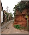
Footpath, Clyst St Mary
Sowton Footpath 4 leaves the former main road by this sandstone cliff.
Image: © Derek Harper
Taken: 31 Jan 2009
0.06 miles
8
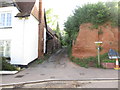
Footpath to Bishop's Court Lane
Public right of way, Sowton footpath 4.
Image: © Peter Holmes
Taken: 7 May 2014
0.06 miles
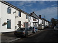
9
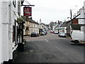
Main Street, Clyst St. Mary
Looking east from the Half Moon pub.
Image: © Jonathan Billinger
Taken: 1 Dec 2009
0.06 miles
10
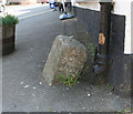
Old Boundary Marker in Clyst St Mary
Parish Boundary Marker by the UC road (was A3052), in parish of Clyst St Mary (Exeter District), at corner of village shop (Londis), opposite Wells House, in path, against corner.
Inscription reads:-
: SOWTON / P : : ST / MARY / CLYST / P :
Surveyed
Milestone Society National ID: DV_EXLR02pb
Image: © Alan Rosevear
Taken: 18 Apr 2011
0.06 miles