IMAGES TAKEN NEAR TO
Clyst St. Mary, EXETER, EX5 1AT
Introduction
This page details the photographs taken nearby to EX5 1AT by members of the Geograph project.
The Geograph project started in 2005 with the aim of publishing, organising and preserving representative images for every square kilometre of Great Britain, Ireland and the Isle of Man.

There are currently over 7.5m images from over14,400 individuals and you can help contribute to the project by visiting https://www.geograph.org.uk
Image Map
Images are licensed for reuse under creativecommons.org/licenses/by-sa/2.0
Notes
- Clicking on the map will re-center to the selected point.
- The higher the marker number, the further away the image location is from the centre of the postcode.
Image Listing (18 Images Found)
Images are licensed for reuse under creativecommons.org/licenses/by-sa/2.0
Image
Details
Distance
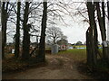
1
Entrance to Winslade Park
A large house and buildings converted in to conference and office spaces.
Image: © Anthony Vosper
Taken: 28 Jan 2023
0.08 miles
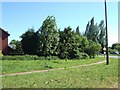
2
Welcome to Clyst Valley FC
Playing in the Devon and Exeter Premier league.
Image: © Anthony Vosper
Taken: 28 Jan 2023
0.10 miles
3
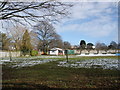
Clyst Valley FC
Members of the Devon and Exeter Football League.
Image: © Roger Cornfoot
Taken: 7 Feb 2009
0.10 miles
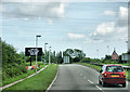
4
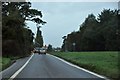
East Devon : Exmouth Road A376
The road heading towards Exeter from Exmouth.
Image: © Lewis Clarke
Taken: 22 Oct 2013
0.12 miles
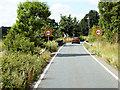
5
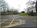
Clyst St Mary roundabout
Looking south from A3052 entry to roundabout, showing close-cropped verges for good visibility
Image: © David Smith
Taken: 3 Jun 2010
0.16 miles
6
A376 Exmouth Road crossing Grindle Brook
The bridge over Grindle Brook at Clyst St Mary.
Image: © David Dixon
Taken: 23 Jul 2018
0.18 miles
7
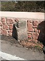
Parish Boundary Marker by the A376, Exmouth Road, Winslade
Parish Boundary Marker by the A376, in parish of Clyst St Mary (Exeter District), Winslade, bridge over stream, on North-bound carriageway, South of Winslade Park, in the stone wall of on Southeast edge of bridge parapet (newly set in 2012).
Inscription reads:
: (St) / Mary / Clist / P : : St / Georges / Clist / P :
Surveyed
Milestone Society National ID: DV_EXEM04pb
Image: © Alan Rosevear
Taken: 27 Mar 2012
0.19 miles

9
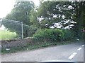
Bridge over Grindle Brook, Clyst St Mary
The parapet of the wall is visible from one carriageway of the A376.
Image: © David Smith
Taken: 2 Sep 2010
0.20 miles
10
A376, Clyst St Mary
Approaching Clyst St Mary junction from the west.
Image: © Pierre Terre
Taken: 20 Jun 2009
0.20 miles