IMAGES TAKEN NEAR TO
Acland Road, EXETER, EX4 6PB
Introduction
This page details the photographs taken nearby to Acland Road, EX4 6PB by members of the Geograph project.
The Geograph project started in 2005 with the aim of publishing, organising and preserving representative images for every square kilometre of Great Britain, Ireland and the Isle of Man.

There are currently over 7.5m images from over14,400 individuals and you can help contribute to the project by visiting https://www.geograph.org.uk
Image Map
Images are licensed for reuse under creativecommons.org/licenses/by-sa/2.0
Notes
- Clicking on the map will re-center to the selected point.
- The higher the marker number, the further away the image location is from the centre of the postcode.
Image Listing (568 Images Found)
Images are licensed for reuse under creativecommons.org/licenses/by-sa/2.0
Image
Details
Distance
1

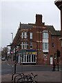
Co-op, Sidwell Street, Exeter
This distinctive building is at the corner of York Road, and can be seen in Image
Image: © Derek Harper
Taken: 6 Jan 2009
0.01 miles
2
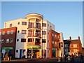
Co-op, Sidwell Street, Exeter
The colourful postmodernism of Image is enhanced by the morning sun. York Road is to the right.
Image: © Derek Harper
Taken: 6 Jan 2009
0.01 miles
3
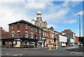
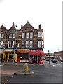
Corner of York Road and Sidwell Street
Older buildings along the far end of Sidwell Street beyond the area devastated by bombing in WW2.
The turreted building is Sidwell Street Methodist Church.
Image: © Des Blenkinsopp
Taken: 22 Aug 2016
0.01 miles
4

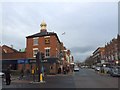
Duke of York and Methodist Church, Exeter
The baroque stylings of the 1905 church, with its octagon and cupola, rear above the Duke of York pub at the corner of York Road and Sidwell Street.
Image: © Derek Harper
Taken: 12 Dec 2006
0.02 miles
5
The Duke of York inn and Sidwell Street Exeter
Image: © David Smith
Taken: 29 Dec 2012
0.02 miles
6

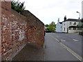
York Road, Exeter
Seen from outside the Spiritualist Church, the side wall of the car park is also the back wall of the properties in Acland Road. This wall shows piecemeal construction and reconstruction, using local stone, possibly local brick at the left hand end, and modern brick elsewhere
Image: © David Smith
Taken: 6 Jun 2015
0.02 miles
7
York Road, Exeter
On the right is Oxford Road and then Well Street (named for St Sidwell's well) and beyond the tree is St Sidwell's Church of England Primary School. The wall shows signs of piecemeal construction and repair using local stone and bricks
Image: © David Smith
Taken: 6 Jun 2015
0.02 miles
8
Pigeons lined up along a roof ridge, Sidwell Street, Exeter
There must have been some reason for the birds gathering along the ridge of the nearest building!
Image: © David Smith
Taken: 29 Mar 2022
0.02 miles
9
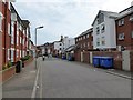
Acland Road, Exeter
A cul-de-sac near St Sidwell's church, Exeter. On the right there are flats between this road and Sidwell Street, with rear entrances to the shops
Image: © David Smith
Taken: 17 Apr 2015
0.02 miles
10
An unusual window in Sidwell Street, Exeter
The window on the corner offers a panorama of a busy road junction; it is one feature of the ornate row of shop buildings seen here.
Image: © David Smith
Taken: 29 Dec 2012
0.02 miles