IMAGES TAKEN NEAR TO
Sheppard Road, EXETER, EX4 5DD
Introduction
This page details the photographs taken nearby to Sheppard Road, EX4 5DD by members of the Geograph project.
The Geograph project started in 2005 with the aim of publishing, organising and preserving representative images for every square kilometre of Great Britain, Ireland and the Isle of Man.

There are currently over 7.5m images from over14,400 individuals and you can help contribute to the project by visiting https://www.geograph.org.uk
Image Map
Images are licensed for reuse under creativecommons.org/licenses/by-sa/2.0
Notes
- Clicking on the map will re-center to the selected point.
- The higher the marker number, the further away the image location is from the centre of the postcode.
Image Listing (30 Images Found)
Images are licensed for reuse under creativecommons.org/licenses/by-sa/2.0
Image
Details
Distance
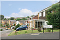
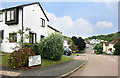
1

The view from Glen Walk
Looking over towards Sheppard Road.
Image: © Chris Denny
Taken: 26 Feb 2009
0.04 miles
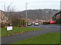
2
Aldrin Road
By the look of the houses, this area would have been under development around the time of the first landing on the moon in 1969.
Adjacent street names commemorate the astronauts. This is (Buzz) Aldrin Road, which together with (Neil) Armstrong Avenue both lead off (Michael) Collins Road.
Image: © Des Blenkinsopp
Taken: 27 Aug 2016
0.10 miles
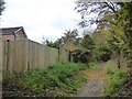
3

Bridleway north of Pennsylvania, Exeter
The housing estate of Pennsylvania is on the left, farmland on the right
Image: © David Smith
Taken: 27 Oct 2016
0.12 miles
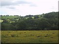
4

Permissive bridleway, Rollestone
A pre-leaf view of the scene in Image, as the path drops into the valley of the Minchinglake Stream.
Image: © Derek Harper
Taken: 16 Mar 2006
0.13 miles
5
Collins Road, Exeter
Named after the Apollo 11 astronaut Michael Collins. There is also an Armstrong Avenue and a Aldrin Road nearby.
Image: © Rob Purvis
Taken: 7 Dec 2008
0.14 miles

7
Bridleway passing gardens in Pennsylvania, Exeter
The old lane is the northern boundary of the Pennsylvania housing estate, developed in the late 20th century
Image: © David Smith
Taken: 27 Oct 2016
0.15 miles
8
Field of buttercups by the track to Lower Rollestone
Image: © Sarah Charlesworth
Taken: 22 May 2009
0.16 miles
9
Stoke Valley Road
Leading to Queensland Drive, Canberra Close and Perth Close.
We must be in the Australian part of town.
Image: © Des Blenkinsopp
Taken: 27 Aug 2016
0.16 miles
10
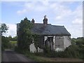
Derelict House by the track to Lower Rollestone
Image: © Sarah Charlesworth
Taken: 22 May 2009
0.17 miles