IMAGES TAKEN NEAR TO
St. Davids Place, Red Cow Village, EXETER, EX4 4AU
Introduction
This page details the photographs taken nearby to St. Davids Place, Red Cow Village, EX4 4AU by members of the Geograph project.
The Geograph project started in 2005 with the aim of publishing, organising and preserving representative images for every square kilometre of Great Britain, Ireland and the Isle of Man.

There are currently over 7.5m images from over14,400 individuals and you can help contribute to the project by visiting https://www.geograph.org.uk
Image Map
Images are licensed for reuse under creativecommons.org/licenses/by-sa/2.0
Notes
- Clicking on the map will re-center to the selected point.
- The higher the marker number, the further away the image location is from the centre of the postcode.
Image Listing (600 Images Found)
Images are licensed for reuse under creativecommons.org/licenses/by-sa/2.0
Image
Details
Distance
1
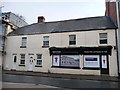
Student flats and studios, Red Cow Village
For sale, not rent. See http://www.exetermemories.co.uk/em/_pubs/artful.php for a photo of these buildings in a previous incarnation.
Image: © Christine Johnstone
Taken: 29 Mar 2014
0.01 miles
2
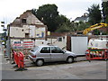
Site of the Former Artful Dodger public house
Known as The John Bull until 1980 and Seamus O'Donnells from 2009, The Artful Dodger was finally demolished in 2011
Image: © Brian Henley
Taken: 11 Aug 2011
0.01 miles
3
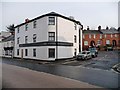
The Artful Dodger House, Red Cow Village
Student housing on the site of a pub, see http://www.exetermemories.co.uk/em/_pubs/artful.php for more information.
Image: © Christine Johnstone
Taken: 29 Mar 2014
0.01 miles
4

The Artful Dodger House, Exeter
Student accommodation on the corner of Cowley Bridge Road and Taddiford Road.
This corner was formerly occupied by the Artful Dodger pub (earlier named the John Bull).
Image: © Jaggery
Taken: 26 Aug 2016
0.01 miles
5

Great Western Hotel, Exeter
Located opposite Exeter St Davids railway station.
Image: © Jaggery
Taken: 26 Aug 2016
0.02 miles
6
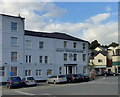
Great Western Hotel, Exeter
Outside St David's station.
Image: © Robert Eva
Taken: 27 Jul 2017
0.02 miles
7
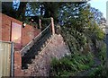
Footpath to Taddyforde
A rather neglected little path linking Cowley Bridge Road with New North Road. The sign on the left proclaims it a public footpath, although it doesn't currently appear as one on Devon's footpath map or the 1:25000 sheet, though I feel sure it has been shown on the latter in the past.
Image: © Derek Harper
Taken: 7 Nov 2008
0.02 miles
8
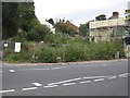
Site of the Former Red Cow Inn
This is the location of the Red Cow Inn, the public house from which this area of Exeter gets its name. It was demolished in 2006.
Image: © Brian Henley
Taken: 11 Aug 2011
0.02 miles
10

Great Western Hotel, Exeter
A long-established hotel close to St David's railway station
Image: © David Smith
Taken: 14 Sep 2013
0.02 miles