IMAGES TAKEN NEAR TO
St. Albans Close, EXETER, EX4 2NE
Introduction
This page details the photographs taken nearby to St. Albans Close, EX4 2NE by members of the Geograph project.
The Geograph project started in 2005 with the aim of publishing, organising and preserving representative images for every square kilometre of Great Britain, Ireland and the Isle of Man.

There are currently over 7.5m images from over14,400 individuals and you can help contribute to the project by visiting https://www.geograph.org.uk
Image Map
Images are licensed for reuse under creativecommons.org/licenses/by-sa/2.0
Notes
- Clicking on the map will re-center to the selected point.
- The higher the marker number, the further away the image location is from the centre of the postcode.
Image Listing (25 Images Found)
Images are licensed for reuse under creativecommons.org/licenses/by-sa/2.0
Image
Details
Distance
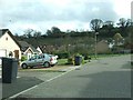
1

Chelmsford Road from Lichfield Road
All the roads in this suburb are named after cathedrals.
Image: © Christine Johnstone
Taken: 29 Mar 2014
0.08 miles
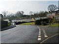
2

Junction of Redhills and Lichfield Road
The footpath has been routed well away from the road on the edge of the Redhills housing estate
Image: © David Smith
Taken: 31 Mar 2011
0.09 miles
3

Gloucester Road, from Redhills
Looking over the top of Westminster Road and Chelmsford Road.
Image: © Christine Johnstone
Taken: 29 Mar 2014
0.09 miles
4

Gloucester Road, Exeter, from Redhills
Part of the western Exeter suburb of Exwick seen from Redhills, with Gloucester Road curving across a northing gridline into Image Across the Exe valley is university accommodation, mostly in Image
Image: © Derek Harper
Taken: 2 Mar 2010
0.09 miles
5
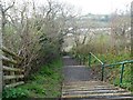
Dukes Walk, looking south
Dropping down to St Peter's Mount.
Image: © Christine Johnstone
Taken: 29 Mar 2014
0.13 miles
6
Lichfield Road
At the junction with Ely Close. All the roads in this suburb are named after cathedrals.
Image: © Christine Johnstone
Taken: 29 Mar 2014
0.13 miles
7
Exeter : St Peter's Mount
Looking up St Peter's Mount on the outskirts of Exeter.
Image: © Lewis Clarke
Taken: 3 Jul 2012
0.15 miles
8
Antonine Crescent leading to Hadrian Drive
A reminder of Roman walls on the south side of Redhills, Exeter.
Image: © Christine Johnstone
Taken: 29 Mar 2014
0.15 miles
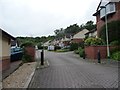
9
St Peter's Mount near Lugg's Farm
A residential road on the edge of Exeter's Redhills district
Image: © David Smith
Taken: 31 Mar 2011
0.16 miles
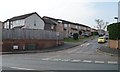
10
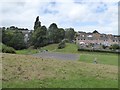
Open space and playground, Redhills, Exeter
The valley between Redhills and Exwick. The nearby houses are in Lincoln Road
Image: © David Smith
Taken: 7 Aug 2016
0.16 miles