IMAGES TAKEN NEAR TO
Hartland, BIDEFORD, EX39 6HW
Introduction
This page details the photographs taken nearby to EX39 6HW by members of the Geograph project.
The Geograph project started in 2005 with the aim of publishing, organising and preserving representative images for every square kilometre of Great Britain, Ireland and the Isle of Man.

There are currently over 7.5m images from over14,400 individuals and you can help contribute to the project by visiting https://www.geograph.org.uk
Image Map
Images are licensed for reuse under creativecommons.org/licenses/by-sa/2.0
Notes
- Clicking on the map will re-center to the selected point.
- The higher the marker number, the further away the image location is from the centre of the postcode.
Image Listing (12 Images Found)
Images are licensed for reuse under creativecommons.org/licenses/by-sa/2.0
Image
Details
Distance
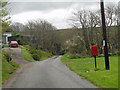
2
Cottage and lane at South Hole, Devon
This is Mole Cottage and the lane leads towards Welcombe, with a fork off towards Lutsford at the bottom of the hill. Both routes become seriously narrow and/or rough in some places!
Image: © Roger D Kidd
Taken: 27 Jun 2015
0.08 miles
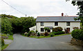
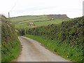
3

Road through South Hole in Devon
This shows the road passing Mole Cottage on its way towards Welcombe. There is with a fork left towards Lutsford at the bottom of the hill. Both routes become seriously narrow and/or rough in some places!
Image: © Roger D Kidd
Taken: 27 Jun 2015
0.09 miles
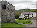
5
Road through South Hole in Devon
This sometimes narrow lane continues northwards towards Elmscott, Stoke and Hartland.
Image: © Roger D Kidd
Taken: 27 Jun 2015
0.11 miles
6
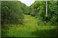
Buttercup Meadow
Lush valley-bottom grassland.
Image: © Tony Atkin
Taken: 30 May 2010
0.12 miles
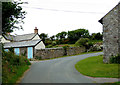
8
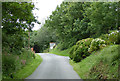
Road approaching South Hole, Devon
This is the lane from Welcombe. It is not all as wide and well maintained as this section!
Image: © Roger D Kidd
Taken: 27 Jun 2015
0.13 miles
9

Stream by South Hole, Devon
Most watercourses are unnamed on local OS maps. This one joins others to flow into the sea at Welcombe Mouth.
Image: © Roger D Kidd
Taken: 27 Jun 2015
0.14 miles
10

Grass fields near South Hole, Devon
The cliff on the skyline is at Embury Beacon.
Image: © Roger D Kidd
Taken: 27 Jun 2015
0.14 miles