IMAGES TAKEN NEAR TO
Welcombe, BIDEFORD, EX39 6HE
Introduction
This page details the photographs taken nearby to EX39 6HE by members of the Geograph project.
The Geograph project started in 2005 with the aim of publishing, organising and preserving representative images for every square kilometre of Great Britain, Ireland and the Isle of Man.

There are currently over 7.5m images from over14,400 individuals and you can help contribute to the project by visiting https://www.geograph.org.uk
Image Map (Loading...)


Getting Data...Please wait
Leaflet Map data © OpenStreetMap
Images are licensed for reuse under creativecommons.org/licenses/by-sa/2.0
Notes
- Clicking on the map will re-center to the selected point.
- The higher the marker number, the further away the image location is from the centre of the postcode.
Image Listing (7 Images Found)
Images are licensed for reuse under creativecommons.org/licenses/by-sa/2.0
Image
Details
Distance

3
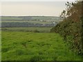
Field by Upcott Cross
This field complements the one shown in Image; the hedges on the left and right, respectively, of the two photos, enclose the lane to Henaford. The other field is currently full of standing maize, so Henaford is invisible (September 2008).
Image: © Derek Harper
Taken: 25 Sep 2008
0.12 miles

6
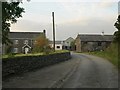
Upcott Farm
At the northern end of a little hamlet on the northern side of the Marsland Water valley.
Image: © Derek Harper
Taken: 25 Sep 2008
0.20 miles
