IMAGES TAKEN NEAR TO
Hartland, BIDEFORD, EX39 6EE
Introduction
This page details the photographs taken nearby to EX39 6EE by members of the Geograph project.
The Geograph project started in 2005 with the aim of publishing, organising and preserving representative images for every square kilometre of Great Britain, Ireland and the Isle of Man.

There are currently over 7.5m images from over14,400 individuals and you can help contribute to the project by visiting https://www.geograph.org.uk
Image Map (52 Images)


Getting Data...Please wait
Leaflet Map data © OpenStreetMap
Images are licensed for reuse under creativecommons.org/licenses/by-sa/2.0
Notes
- Clicking on the map will re-center to the selected point.
- The higher the marker number, the further away the image location is from the centre of the postcode.
Image Listing (52 Images Found)
Images are licensed for reuse under creativecommons.org/licenses/by-sa/2.0
Image
Details
Distance
1
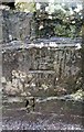
Ordnance Survey Cut Mark
This OS cut mark can be found on the SE parapet of the bridge. It marks a point 102.867m above mean sea level.
Image: © Adrian Dust
Taken: 22 Jan 2018
0.05 miles
2
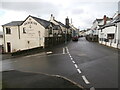
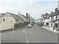
The road to Bude
Looking westwards down Fore Street, Hartland. The Anchor Inn http://www.theanchorinnhartland.co.uk/ occupies a prominent position on the street corner. Hartland has a one-way system which loops through most of the village, starting at this junction with the left turn into Fore Street from the Bude road.
Image: © HelenK
Taken: 24 Dec 2020
0.07 miles

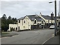
6
Fore Street, Hartland
From its junction with Ford Hill.
Image: © John Baker
Taken: 27 Mar 2013
0.10 miles
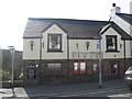
7

Fore Street, Hartland
Looking east away from the village centre past the Anchor Inn on the right hand side.
Image: © Jonathan Billinger
Taken: 13 Sep 2015
0.10 miles
8
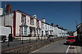
Fore St Hartland
There is a considerable raised pavement outside this row of terraced houses as a result of the steep slope.
Image: © Nigel Mykura
Taken: 23 May 2017
0.11 miles
9

Fore Street, Hartland
The last building that is visible on the left is the village post office
Image: © David Smith
Taken: 19 Aug 2013
0.11 miles
10

Hartland village in Devon
This telephoto assisted image shows part of eastern Hartland seen from a distance of about five hundred metres.
Image: © Roger D Kidd
Taken: 30 Jun 2015
0.11 miles