IMAGES TAKEN NEAR TO
Springfield, BIDEFORD, EX39 6BG
Introduction
This page details the photographs taken nearby to Springfield, EX39 6BG by members of the Geograph project.
The Geograph project started in 2005 with the aim of publishing, organising and preserving representative images for every square kilometre of Great Britain, Ireland and the Isle of Man.

There are currently over 7.5m images from over14,400 individuals and you can help contribute to the project by visiting https://www.geograph.org.uk
Image Map (Loading...)


Getting Data...Please wait
Leaflet Map data © OpenStreetMap
Images are licensed for reuse under creativecommons.org/licenses/by-sa/2.0
Notes
- Clicking on the map will re-center to the selected point.
- The higher the marker number, the further away the image location is from the centre of the postcode.
Image Listing (49 Images Found)
Images are licensed for reuse under creativecommons.org/licenses/by-sa/2.0
Image
Details
Distance
1
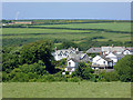
Hartland village in Devon
This telephoto assisted image shows part of western Hartland seen from a distance of about six hundred metres.
Image]
Image: © Roger D Kidd
Taken: 30 Jun 2015
0.01 miles
2
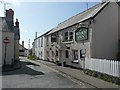
The Hart Inn, Hartland
In the narrow street leading from the top end of the former market place.
Image: © Humphrey Bolton
Taken: 8 May 2009
0.02 miles
3
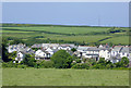
Hartland village in Devon
This telephoto assisted image shows part of western Hartland seen from a distance of about five hundred metres.
Image]
Image: © Roger D Kidd
Taken: 30 Jun 2015
0.02 miles
4

Very convenient
These loos have to be the best maintained and cleaned in the West Country?
Hartland village, take a bow!
Image: © Jonathan Billinger
Taken: 13 Sep 2015
0.03 miles
5
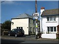
West Street, Hartland
One wonders why the indicator boards were placed so high. Was it to protect them from vandalism or accident, or to leave space for the pole to be used for advertising?
Image: © David Smith
Taken: 19 Aug 2013
0.03 miles
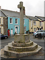
6

West Street Hartland
This is the centre of the village looking up West Street towards the Square from the junction of West Street and North Street. A liberal democrat general election poster is prominent with a smaller Labour one above it.
Image: © Nigel Mykura
Taken: 23 May 2017
0.04 miles
7
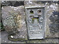
Ordnance Survey Flush Bracket S5421
This can be found on the roadside wall of The Chapel of St John in Hartland.
For more detail see : http://www.bench-marks.org.uk/bm20837 and http://www.britishlistedbuildings.co.uk/en-91250-chapel-of-st-john-hartland-devon#.VkxGDr_xQg4
Image: © Peter Wood
Taken: 3 Apr 2015
0.04 miles
9
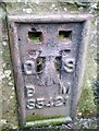
Ordnance Survey Flush Bracket (S5421)
This OS Flush Bracket can be found on the SW angle of the St John's Chapel. It marks a point 112.882m above mean sea level.
Image: © Adrian Dust
Taken: 22 Jan 2018
0.04 miles
