IMAGES TAKEN NEAR TO
Woolsery, BIDEFORD, EX39 5RE
Introduction
This page details the photographs taken nearby to EX39 5RE by members of the Geograph project.
The Geograph project started in 2005 with the aim of publishing, organising and preserving representative images for every square kilometre of Great Britain, Ireland and the Isle of Man.

There are currently over 7.5m images from over14,400 individuals and you can help contribute to the project by visiting https://www.geograph.org.uk
Image Map
Images are licensed for reuse under creativecommons.org/licenses/by-sa/2.0
Notes
- Clicking on the map will re-center to the selected point.
- The higher the marker number, the further away the image location is from the centre of the postcode.
Image Listing (1 Images Found)
Images are licensed for reuse under creativecommons.org/licenses/by-sa/2.0
Image
Details
Distance
1
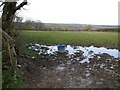
Field at Ashmansworthy
Ashmansworthy is on a hill between a tributary of Dipple Water, towards which this long rectangular field slopes, and the Torridge. Taken from the side of an area on the east side of the hamlet that might have been a green or a pound, beside the lane to Dipple.
Image: © Derek Harper
Taken: 27 Mar 2008
0.14 miles