IMAGES TAKEN NEAR TO
Buckland Brewer, BIDEFORD, EX39 5LY
Introduction
This page details the photographs taken nearby to EX39 5LY by members of the Geograph project.
The Geograph project started in 2005 with the aim of publishing, organising and preserving representative images for every square kilometre of Great Britain, Ireland and the Isle of Man.

There are currently over 7.5m images from over14,400 individuals and you can help contribute to the project by visiting https://www.geograph.org.uk
Image Map
Images are licensed for reuse under creativecommons.org/licenses/by-sa/2.0
Notes
- Clicking on the map will re-center to the selected point.
- The higher the marker number, the further away the image location is from the centre of the postcode.
Image Listing (13 Images Found)
Images are licensed for reuse under creativecommons.org/licenses/by-sa/2.0
Image
Details
Distance
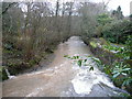
1
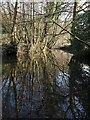
River Duntz at Buckland Mill
Looking up the Duntz from its confluence with the Buckland Brewer stream, by the bridge. The river is in more peaceful mood than in Image
Image: © Derek Harper
Taken: 16 Feb 2008
0.05 miles
2

Under Buckland Mill bridge
Looking upstream. The scene in Image is in the background.
Image: © Derek Harper
Taken: 16 Feb 2008
0.06 miles
3
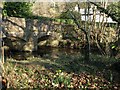
Bridge, Buckland Mill
Two of the arches of the bridge across the River Duntz. The river is flowing to the left. Taken from a strip of land, with wild daffodils, between the Buckland stream tributary and the mill leat.
Image: © Derek Harper
Taken: 16 Feb 2008
0.06 miles
4
Road junction beside the River Duntz
Road junction beside the River Duntz to the east of Buckland Brewer.
Image: © Philip Halling
Taken: 10 Apr 2015
0.06 miles
5
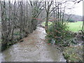
River Duntz - upstream
Looking south from near The Glen.
Image: © Jonathan Billinger
Taken: 16 Jan 2008
0.07 miles
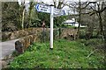
6

Bridge at Buckland Mill
This is the bridge seen in Image from the opposite direction, rather than Image, which is just off to the right. It crosses the stream descending to join the Duntz from below Buckland Brewer village. In the background is a road junction where lanes meet from Buckland Brewer, Hele, and Frithelstock Stone.
Image: © Derek Harper
Taken: 16 Feb 2008
0.08 miles
7
River Duntz - downstream
Looking north near The Glen.
Image: © Jonathan Billinger
Taken: 16 Jan 2008
0.08 miles
8

Road passing Buckland Mill
Buckland Mill can be seen in the background. For a similar view back in January 2008 see: Image]
Image: © Philip Halling
Taken: 10 Apr 2015
0.08 miles
9

Buckland Brewer: Buckland Mill
Seen in September 1994
Image: © Martin Bodman
Taken: Unknown
0.10 miles
10

House at Buckland Mill
This is the building seen at the right of Image, facing the old mill. The lane climbs steeply towards Hele.
Image: © Derek Harper
Taken: 16 Feb 2008
0.10 miles