IMAGES TAKEN NEAR TO
Gammaton, BIDEFORD, EX39 4QQ
Introduction
This page details the photographs taken nearby to EX39 4QQ by members of the Geograph project.
The Geograph project started in 2005 with the aim of publishing, organising and preserving representative images for every square kilometre of Great Britain, Ireland and the Isle of Man.

There are currently over 7.5m images from over14,400 individuals and you can help contribute to the project by visiting https://www.geograph.org.uk
Image Map
Images are licensed for reuse under creativecommons.org/licenses/by-sa/2.0
Notes
- Clicking on the map will re-center to the selected point.
- The higher the marker number, the further away the image location is from the centre of the postcode.
Image Listing (3 Images Found)
Images are licensed for reuse under creativecommons.org/licenses/by-sa/2.0
Image
Details
Distance
1
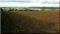
Gammaton Barton
The cluster of farm buildings seen across an arable field. The tiny white triangle is the gable end of the farmhouse catching the sun. Just to the right of it, a pheasant is searching for whatever's been planted. A fine view beyond takes in Appledore in the centre near the confluence of the Torridge and the Taw, with Baggy Point in the distance.
Image: © Derek Harper
Taken: 1 Dec 2019
0.23 miles
2
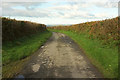
Lane to Gammaton
The lane has reached a high point at about 140 metres.
Image: © Derek Harper
Taken: 1 Dec 2019
0.24 miles
3

Woodtown House, Woodtown, Near Bideford
Image: © Roger A Smith
Taken: 12 Jan 2006
0.25 miles