IMAGES TAKEN NEAR TO
Gammaton, BIDEFORD, EX39 4QF
Introduction
This page details the photographs taken nearby to EX39 4QF by members of the Geograph project.
The Geograph project started in 2005 with the aim of publishing, organising and preserving representative images for every square kilometre of Great Britain, Ireland and the Isle of Man.

There are currently over 7.5m images from over14,400 individuals and you can help contribute to the project by visiting https://www.geograph.org.uk
Image Map
Images are licensed for reuse under creativecommons.org/licenses/by-sa/2.0
Notes
- Clicking on the map will re-center to the selected point.
- The higher the marker number, the further away the image location is from the centre of the postcode.
Image Listing (24 Images Found)
Images are licensed for reuse under creativecommons.org/licenses/by-sa/2.0
Image
Details
Distance
1
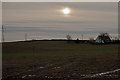
Former council houses in the late afternoon winter sun
Image: © Roger A Smith
Taken: 25 Dec 2019
0.00 miles
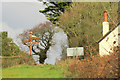
2
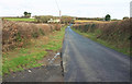
Lane to Gammaton Moor
The stretch of road shown in Image, but without the sunshine. The red car is at the junction with the lane from Huxhill, where there is a milestone https://www.geograph.org.uk/gridref/SS4924?centi=SS490242 ; the house is therefore Milestone Cottage. All these are in Image
Image: © Derek Harper
Taken: 1 Dec 2019
0.07 miles
3
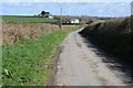
Road approaching Gammaton Moor
Country road approaching the small hamlet of Gammaton Moor.
Image: © Philip Halling
Taken: 11 Apr 2015
0.08 miles
4
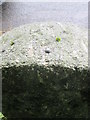
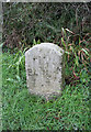
Ordnance Survey Rivet
This OS rivet can be found on the top of the milestone. It marks a point 130.339m above mean sea level. http://www.geograph.org.uk/photo/4567030
Image: © Adrian Dust
Taken: 12 Jul 2015
0.10 miles
5
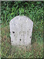
Milestone - Barnstaple 11
There is an Ordnance Survey on the top of the stone. http://www.geograph.org.uk/photo/4567024
Image: © Adrian Dust
Taken: 12 Jul 2015
0.10 miles
6
Old Milestone south of Gammaton Moor Cross
Carved stone post by the UC road, in parish of WEARE GIFFARD (TORRIDGE District), just South of Gammerton Moor Cross, by "Milestone", at Y-junction, opposite fingerpost, on West side of road. Barum tombstone, erected by the Barnstaple turnpike trust in the 19th century.
Inscription reads:-
11
BARUM
BY
BIDEFORD
Rivet on top.
Grade II Listed. List Entry Number:1305504
https://historicengland.org.uk/listing/the-list/list-entry/1305504
Milestone Society National ID: DV_BSBB11.
Image: © A Rosevear
Taken: 6 Feb 2012
0.10 miles
7

Lane to Gammaton Moor
From Huxhill, and just breasting a high spot.
Image: © Derek Harper
Taken: 1 Dec 2019
0.11 miles
8
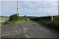
An un-named road junction near Weare Giffard
Image: © Roger A Smith
Taken: 23 Sep 2023
0.14 miles
9
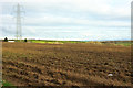
Farmland southeast of Gammaton Moor
Looking right from Image The house on the left is Gammaton - to the right of it is the Methodist church http://www.geograph.org.uk/search.php?i=116526198 .
Image: © Derek Harper
Taken: 1 Dec 2019
0.15 miles
10
Gammaton Moor Cross
A detail of Image], with the listed signpost https://historicengland.org.uk/listing/the-list/list-entry/1460098 and, on the right, Gammaton Lodge.
Image: © Derek Harper
Taken: 1 Dec 2019
0.17 miles