IMAGES TAKEN NEAR TO
Alverdiscott Road, BIDEFORD, EX39 4PN
Introduction
This page details the photographs taken nearby to Alverdiscott Road, EX39 4PN by members of the Geograph project.
The Geograph project started in 2005 with the aim of publishing, organising and preserving representative images for every square kilometre of Great Britain, Ireland and the Isle of Man.

There are currently over 7.5m images from over14,400 individuals and you can help contribute to the project by visiting https://www.geograph.org.uk
Image Map
Images are licensed for reuse under creativecommons.org/licenses/by-sa/2.0
Notes
- Clicking on the map will re-center to the selected point.
- The higher the marker number, the further away the image location is from the centre of the postcode.
Image Listing (20 Images Found)
Images are licensed for reuse under creativecommons.org/licenses/by-sa/2.0
Image
Details
Distance
1
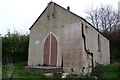
A disused Mission Church on the Alverdiscott Road, between East the Water & Woodtown.
This church is marked on a map dated 1909.
Image: © Roger A Smith
Taken: 22 Apr 2009
0.04 miles
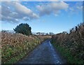
2

Derelict chapel
A derelict and overgrown chapel beside a country road near Woodtown.
Image: © Philip Halling
Taken: 11 Apr 2015
0.05 miles
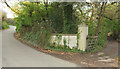
4
Entrance and drive to Portobello
Entrance and drive to Portobello near East-The-Water.
Image: © Philip Halling
Taken: 11 Apr 2015
0.14 miles
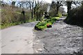
5
Alverdiscott Road
The entrance to Port Farm veers off to the right.
Image: © Derek Harper
Taken: 1 Dec 2019
0.14 miles
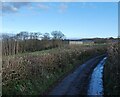
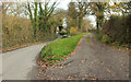
7
Lane to Eastwood
The no through road sets out from Eastwood Cross.
Image: © Derek Harper
Taken: 1 Dec 2019
0.15 miles
8
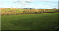
Farmland near Eastwood
Looking right from Image
Image: © Derek Harper
Taken: 1 Dec 2019
0.15 miles
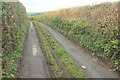
9
Lane from Eastwood
A reverse view of Image], with a glimpse of the junction with Alverdiscott Road.
Image: © Derek Harper
Taken: 1 Dec 2019
0.16 miles
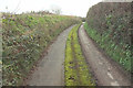
10
Entrance on Alverdiscott Road
Looking the other way from Image The entrance drive is to Warmington Hill.
Image: © Derek Harper
Taken: 1 Dec 2019
0.18 miles