IMAGES TAKEN NEAR TO
Westleigh, BIDEFORD, EX39 4NX
Introduction
This page details the photographs taken nearby to EX39 4NX by members of the Geograph project.
The Geograph project started in 2005 with the aim of publishing, organising and preserving representative images for every square kilometre of Great Britain, Ireland and the Isle of Man.

There are currently over 7.5m images from over14,400 individuals and you can help contribute to the project by visiting https://www.geograph.org.uk
Image Map
Images are licensed for reuse under creativecommons.org/licenses/by-sa/2.0
Notes
- Clicking on the map will re-center to the selected point.
- The higher the marker number, the further away the image location is from the centre of the postcode.
Image Listing (14 Images Found)
Images are licensed for reuse under creativecommons.org/licenses/by-sa/2.0
Image
Details
Distance
1
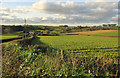
Farmland, Bradavin
Some sort of brassica growing beside the road from Hill Head to Bradavin. Just down the road in front of the farm are Bradavin Cottages, a pair of brick cottages with gardens jutting out into the field.
Image: © Derek Harper
Taken: 1 Dec 2019
0.02 miles
3
Bradavin
Looking more to the right than Image], with overlap. The listed farmhouse https://historicengland.org.uk/listing/the-list/list-entry/1107607 at Bradavin straddles the easting gridline. Again, Mark's Copse is the wood on the valley side.
Image: © Derek Harper
Taken: 1 Dec 2019
0.10 miles
4
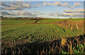
Farmland near Bradavin
Looking right from where Image] was taken, over another part of the brassica crop. On the left are Scoreshill Cottages, in Image
Image: © Derek Harper
Taken: 1 Dec 2019
0.11 miles
5

Lane, Bradavin
Curving down to the Horwood Stream valley.
Image: © Derek Harper
Taken: 1 Dec 2019
0.12 miles

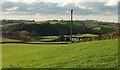
7

Road to Bideford
Heading down the Old Barnstaple Road towards the Horwood Stream valley with Bideford in the distance. Sheep graze a field with an attractive hill in it.
Image: © Derek Harper
Taken: 1 Dec 2019
0.14 miles
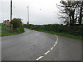
8

The Old Bideford Road near Cobley Lane
Image: © Roger A Smith
Taken: 25 Dec 2016
0.14 miles
9

Farmland near Bradavin
From the junction at Hill Head, looking towards Bideford, with the low hill seen in Image Farm buildings at Bradavin are on the extreme right. Mark's Copse is the wood beyond.
Image: © Derek Harper
Taken: 1 Dec 2019
0.14 miles
10

The Old Bideford Road near Hill Head
Image: © Roger A Smith
Taken: 25 Dec 2016
0.15 miles