IMAGES TAKEN NEAR TO
Westleigh, BIDEFORD, EX39 4NJ
Introduction
This page details the photographs taken nearby to EX39 4NJ by members of the Geograph project.
The Geograph project started in 2005 with the aim of publishing, organising and preserving representative images for every square kilometre of Great Britain, Ireland and the Isle of Man.

There are currently over 7.5m images from over14,400 individuals and you can help contribute to the project by visiting https://www.geograph.org.uk
Image Map
Images are licensed for reuse under creativecommons.org/licenses/by-sa/2.0
Notes
- Clicking on the map will re-center to the selected point.
- The higher the marker number, the further away the image location is from the centre of the postcode.
Image Listing (14 Images Found)
Images are licensed for reuse under creativecommons.org/licenses/by-sa/2.0
Image
Details
Distance

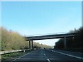
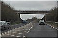
3
Bridge over A39 carrying the road to Ball Hill
Image: © David Smith
Taken: 19 Aug 2013
0.17 miles

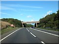
5
North Devon : The A39
The A39 heading through North Devon near Westleigh.
Image: © Lewis Clarke
Taken: 3 Mar 2013
0.18 miles
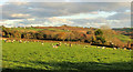
6
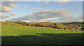
Sheep near Southcott
The field is bounded on the far side by a green lane; the wood, Mark's Copse, is well beyond that. This wide angle view incorporates features of Image], Image] and Image
Image: © Derek Harper
Taken: 1 Dec 2019
0.20 miles
7

Sheep near Southcott
A detail of Image], with a little extra on the left. Mark's Copse is on the right.
Image: © Derek Harper
Taken: 1 Dec 2019
0.20 miles
8
Sheep near Southcott
Image: © Derek Harper
Taken: 1 Dec 2019
0.20 miles

10

The A39 approaching Torridge Bridge
Torridge Bridge is visible to the right, just below the Raleigh Estate. Just above the centre of the image is the Big Sheep and to the left Abbotsham. Below this are houses on the Kenwith Valley estate.
Image: © Roger A Smith
Taken: 4 Sep 2011
0.21 miles