IMAGES TAKEN NEAR TO
North View Avenue, BIDEFORD, EX39 3LJ
Introduction
This page details the photographs taken nearby to North View Avenue, EX39 3LJ by members of the Geograph project.
The Geograph project started in 2005 with the aim of publishing, organising and preserving representative images for every square kilometre of Great Britain, Ireland and the Isle of Man.

There are currently over 7.5m images from over14,400 individuals and you can help contribute to the project by visiting https://www.geograph.org.uk
Image Map (Loading...)


Getting Data...Please wait
Leaflet Map data © OpenStreetMap
Images are licensed for reuse under creativecommons.org/licenses/by-sa/2.0
Notes
- Clicking on the map will re-center to the selected point.
- The higher the marker number, the further away the image location is from the centre of the postcode.
Image Listing (96 Images Found)
Images are licensed for reuse under creativecommons.org/licenses/by-sa/2.0
Image
Details
Distance
1

Northdown Road, Bideford
See also: Image
Northdown Road is in the centre of the image. To the left are the lights of the football pitch and the former buildings of the Stella Maris convent. To the right is the roof of Morrisons supermarket and across the foreground are boats on the river Torridge.
Image: © Roger A Smith
Taken: 26 Dec 2016
0.09 miles

3

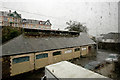
Looking east down Northdown Road during a downpour
See also: Image
Image: © Roger A Smith
Taken: 12 Jan 2017
0.11 miles
4

A burnt-out motorbike in Littlejohn's coal yard
Image: © Roger A Smith
Taken: 27 Nov 2018
0.12 miles
5
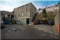
Litlejohn's Coal Yard
This site has known collars, flour and coal and will soon become domestic dwellings.
Image: © Roger A Smith
Taken: 8 Mar 2018
0.12 miles
6
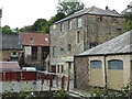
Former collar factory, Bideford
A collection of buildings that formed a shirt collar manufactory and was later in multiple occupancy including a coal merchant and council depot.
Image: © Chris Allen
Taken: 13 Jul 2017
0.13 miles
7
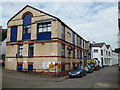
Former collar factory - Bideford
This part of this large former shirt collar factory is now a council depot for waste disposal vehicles.
Image: © Chris Allen
Taken: 13 Jul 2017
0.13 miles
8
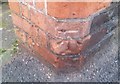
Ordnance Survey Cut Mark
This OS cut mark can be found on the gatepost of Stanhope House. It marks a point 5.173m above mean sea level.
Image: © Adrian Dust
Taken: 6 Dec 2019
0.13 miles
9
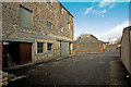
Litlejohn's Coal Yard
This site has known collars, flour and coal and will soon become domestic dwellings.
The building furthest away does not appear on an 1880 map so may not have been part of the collar works.
Image: © Roger A Smith
Taken: 8 Mar 2018
0.13 miles