IMAGES TAKEN NEAR TO
Clovelly Road, BIDEFORD, EX39 3DF
Introduction
This page details the photographs taken nearby to Clovelly Road, EX39 3DF by members of the Geograph project.
The Geograph project started in 2005 with the aim of publishing, organising and preserving representative images for every square kilometre of Great Britain, Ireland and the Isle of Man.

There are currently over 7.5m images from over14,400 individuals and you can help contribute to the project by visiting https://www.geograph.org.uk
Image Map (Loading...)


Getting Data...Please wait
Leaflet Map data © OpenStreetMap
Images are licensed for reuse under creativecommons.org/licenses/by-sa/2.0
Notes
- Clicking on the map will re-center to the selected point.
- The higher the marker number, the further away the image location is from the centre of the postcode.
Image Listing (34 Images Found)
Images are licensed for reuse under creativecommons.org/licenses/by-sa/2.0
Image
Details
Distance
1
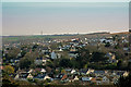
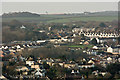
A terrace of houses on Clovelly Road are in the centre of this image
The church in the far distance is St. George's Church, Monkleigh
Image: © Roger A Smith
Taken: 25 Mar 2017
0.01 miles
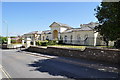
3
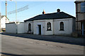
Toll House by Clovelly Road, Bideford
Toll House in the parish of Bideford (Torridge District), Twinaway Bungalow, No. 56, Clovelly Road (Bowden Green).
Grade II listed.
List Entry Number: 1293024 https://historicengland.org.uk/listing/the-list/list-entry/1293024
Surveyed
Milestone Society National ID: DV.BID
Image: © Alan Rosevear
Taken: 12 Feb 2008
0.05 miles
4

'Twinaway bungalow'
Former toll house.
Image: © Roger Cornfoot
Taken: 10 Sep 2020
0.06 miles
5
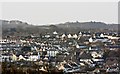
Tricks Allotments and some of Bideford Town
Tricks allotments is in the centre of the image. Below this is the Methodist Church on the High Street. To the left of the allotments are houses on Clovelly Road.
Image: © Roger A Smith
Taken: 26 Dec 2016
0.06 miles

8

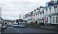
Terrace on Clovelly Road, Bideford
The nearest house appears to have been painted over the typical north Devon glazed bricks, which can be seen on the houses beyond. The gateposts have layers of the white glazed bricks, and the front walls are stone
Image: © David Smith
Taken: 9 Jun 2014
0.12 miles
9

Ordnance Survey Cut Mark
This OS cut mark can be found on the wall of No14 Geneva Place. It marks a point 48.808m above mean sea level.
Image: © Adrian Dust
Taken: 6 Dec 2019
0.16 miles
10
The Old Workhouse and Hospital on Meddon Street
The Union Workhouse on Meddon Street built in about 1836 which later became a hospital.
Image: © Roger A Smith
Taken: 25 Jun 2010
0.16 miles