IMAGES TAKEN NEAR TO
Clovelly Road, BIDEFORD, EX39 3BY
Introduction
This page details the photographs taken nearby to Clovelly Road, EX39 3BY by members of the Geograph project.
The Geograph project started in 2005 with the aim of publishing, organising and preserving representative images for every square kilometre of Great Britain, Ireland and the Isle of Man.

There are currently over 7.5m images from over14,400 individuals and you can help contribute to the project by visiting https://www.geograph.org.uk
Image Map
Images are licensed for reuse under creativecommons.org/licenses/by-sa/2.0
Notes
- Clicking on the map will re-center to the selected point.
- The higher the marker number, the further away the image location is from the centre of the postcode.
Image Listing (49 Images Found)
Images are licensed for reuse under creativecommons.org/licenses/by-sa/2.0
Image
Details
Distance

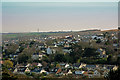
3
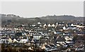
Tricks Allotments and some of Bideford Town
Tricks allotments is in the centre of the image. Below this is the Methodist Church on the High Street. To the left of the allotments are houses on Clovelly Road.
Image: © Roger A Smith
Taken: 26 Dec 2016
0.07 miles
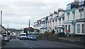
4
A terrace of houses on Clovelly Road are in the centre of this image
The church in the far distance is St. George's Church, Monkleigh
Image: © Roger A Smith
Taken: 25 Mar 2017
0.08 miles
5

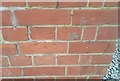
Ordnance Survey Cut Mark
This OS cut mark can be found on the wall of No14 Geneva Place. It marks a point 48.808m above mean sea level.
Image: © Adrian Dust
Taken: 6 Dec 2019
0.08 miles
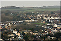
6

Clovelly Road leading away from the junction with Meddon Street (left) and Old Town
Image: © Roger A Smith
Taken: 25 Jun 2010
0.10 miles
7

Meddon Street at the junction with Old Town and Clovelly Road
Image: © Roger A Smith
Taken: 25 Jun 2010
0.10 miles
9
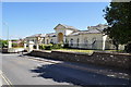
The Old Workhouse and Hospital on Meddon Street
The Union Workhouse on Meddon Street built in about 1836 which later became a hospital.
Image: © Roger A Smith
Taken: 25 Jun 2010
0.11 miles
10
Ordnance Survey Cut Mark
This worn OS cut mark can be found on the SW angle of the old school. It marks a point 47.442m above mean sea level.
Image: © Adrian Dust
Taken: 6 Dec 2019
0.11 miles